Difference between revisions of "Category:ISO Explorer"
| Line 2: | Line 2: | ||
The ISO Metadata Standards (ISO 19115-1, ISO 19157, ...) provide standard metadata and an associated structure that will serve a wide variety of digital geographic data. The definitions and domain values are intended to be sufficiently generic to satisfy the metadata needs of various disciplines. | The ISO Metadata Standards (ISO 19115-1, ISO 19157, ...) provide standard metadata and an associated structure that will serve a wide variety of digital geographic data. The definitions and domain values are intended to be sufficiently generic to satisfy the metadata needs of various disciplines. | ||
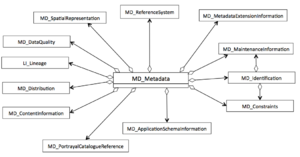
| − | The ISO metadata are organized into a tree structure using the Unified Modeling Language ( | + | The ISO metadata are organized into a tree structure using the Unified Modeling Language ([https://en.wikipedia.org/wiki/Unified_Modeling_Language UML)] and are typically implemented in standard XML (ISO 19115-3, ISO 19157-2). The Figure shows the highest level of the ISO hierarchy. Each section shown here includes a number of elements and related classes that hold standard metadata elements. |
| − | + | The original ISO Explorer was developed at NOAA's National Center for Environmental Information and provides a comprehensive [https://geo-ide.noaa.gov/wiki/index.php?title=MI_Metadata guide] to ISO 19115-2. The ESIP [[Category:Documentation_Cluster|Documentation Cluster]] developed this guide to ISO 19115-1 and ISO 19157. The goal of this effort is top create a series of pages that follow the ISO structure and show the correct order of the elements, links to parents and child elements/objects, obligation, repeatability and references to more information and examples. | |
| + | |||
| + | This page lists all of the other pages that are included in the ISO Explorer. Click a link below to go to a particular page or click [[MD_Metadata]] to start at the top. | ||
| + | |||
| + | Please contact the Documentation Cluster if you can help create this comprehensive guide. | ||
Revision as of 10:21, January 4, 2017
The ISO Metadata Standards (ISO 19115-1, ISO 19157, ...) provide standard metadata and an associated structure that will serve a wide variety of digital geographic data. The definitions and domain values are intended to be sufficiently generic to satisfy the metadata needs of various disciplines.
The ISO metadata are organized into a tree structure using the Unified Modeling Language (UML) and are typically implemented in standard XML (ISO 19115-3, ISO 19157-2). The Figure shows the highest level of the ISO hierarchy. Each section shown here includes a number of elements and related classes that hold standard metadata elements.
The original ISO Explorer was developed at NOAA's National Center for Environmental Information and provides a comprehensive guide to ISO 19115-2. The ESIP developed this guide to ISO 19115-1 and ISO 19157. The goal of this effort is top create a series of pages that follow the ISO structure and show the correct order of the elements, links to parents and child elements/objects, obligation, repeatability and references to more information and examples.
This page lists all of the other pages that are included in the ISO Explorer. Click a link below to go to a particular page or click MD_Metadata to start at the top.
Please contact the Documentation Cluster if you can help create this comprehensive guide.
Pages in category "ISO Explorer"
The following 187 pages are in this category, out of 187 total.
C
D
- Date
- DateTime
- Decimal
- DerivedUnit
- Distance
- DQ ConformanceResult
- DQ DataQuality
- DQ DescriptiveResult
- DQ Element
- DQ EvaluationMethod
- DQ FullInspection
- DQ IndirectEvaluation
- DQ MeasureReference
- DQ QuantitativeResult
- DQ report elements
- DQ Result
- DQ SampleBasedInspection
- DQ Scope
- DQ StandAloneQualityReportInformation
- DQ StandaloneQualityReportInformation
- DS DataSet
- DS Initiative
- DS OtherAggregate
- DS Platform
- DS ProductionSeries
- DS Sensor
- DS Series
- DS StereoMate
E
I
L
M
- MD AggregateInformation
- MD ApplicationSchemaInformation
- MD AssociatedResource
- MD AttributeGroup
- MD Band
- MD BrowseGraphic
- MD Constraints
- MD ContentInformation
- MD CoverageDescription
- MD DataIdentification
- MD DigitalTransferOptions
- MD Dimension
- MD Distribution
- MD Distributor
- MD ExtendedElementInformation
- MD FeatureCatalogue
- MD FeatureCatalogueDescription
- MD FeatureTypeInfo
- MD Format
- MD GeometricObjects
- MD Georectified
- MD Georeferencable.html
- MD Georeferenceable
- MD GridSpatialRepresentation
- MD GridSpatialRepresentation.html
- MD Identification
- MD Identifier
- MD ImageDescription
- MD KeywordClass
- MD Keywords
- MD LegalConstraints
- MD MaintenanceInformation
- MD Medium
- MD Metadata
- MD MetadataExtension
- MD MetadataExtensionInformation
- MD MetadataScope
- MD PortrayalCatalogue
- MD PortrayalCatalogueReference
- MD RangeDimension
- MD ReferenceSystem
- MD Releasability
- MD RepresentativeFraction
- MD Resolution
- MD SampleDimension
- MD Scope
- MD ScopeDescription
- MD SecurityConstraints
- MD SpatialRepresentation
- MD StandardOrderProcess
- MD Usage
- MD VectorSpatialRepresentation
- Measure
- MemberName
- MI AcquisitionInformation
- MI Band
- MI CoverageDescription
- MI EnvironmentalRecord
- MI Event
- MI GCP
- MI GCPCollection
- MI Georectified
- MI Georeferenceable
- MI ImageDescription
- MI Instrument
- MI InstrumentationEvent
- MI InstrumentationEventList
- MI Objective
- MI Operation
- MI Plan
- MI Platform
- MI PlatformPass
- MI RangeElementDescription
- MI RequestedDate
- MI Requirement
- MI Revision
- MI Sensor
- MultiCurve
- MultiPoint
- MX Aggregate
- MX DataFile
- MX DataSet
- MX SupportFile
