Difference between revisions of "MD Metadata"
From Earth Science Information Partners (ESIP)
m (1 revision: Importing the ISO Explorer Category from GEO-IDE Wiki (Ted Habermann)) |
m |
||
| Line 45: | Line 45: | ||
|- bgcolor="FFFF99" | |- bgcolor="FFFF99" | ||
| 7 | | 7 | ||
| − | | [[CI | + | | [[CI Responsibility|contact]] |
| 1..* | | 1..* | ||
| bgcolor="#ffffff" | ''Individual and/or organization responsible for metadata creation and maintenance. Use roleCode="pointOfContact". Provide contact details, such address, phone and email.'' | | bgcolor="#ffffff" | ''Individual and/or organization responsible for metadata creation and maintenance. Use roleCode="pointOfContact". Provide contact details, such address, phone and email.'' | ||
Revision as of 18:31, November 13, 2016
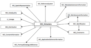
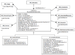
Comprehensive explorer of ISO 19115 and 19115-2 metadata standards. These pages show the correct order of the elements, links to child element/object, obligation, repeatability and references to more information and examples.
|
Elements |
Definition and Recommended Practice | Examples | ||
|---|---|---|---|---|
| fileIdentifier | 0..1 | Value that uniquely identifies this metadata record. This identifer is assigned and maintained by the custodian of the metadata record. Recommended Practice: value of identifier is usually the same as the name of the metadata file - for example C00500.xml. There are two general approaches to ensuring uniqueness for these identifiers: 1. use a universal unique identifier (UUID), to distinguish it from other resources. 2. Include a namespace and a code guarenteed to be unique in that namespace in the identifier. For example: gov.noaa.class:AERO100. In this case gov.noaa.class is a namespace and AERO100 is a code guaranteed to be unique in that namespace. | gov.noaa.ncdc:C00500 | |
| 2 | language | 0..1 | Language of the metadata record composed of as an ISO639-2/T three letter language code and an ISO3166-1 three letter country code. | eng; USA |
| 3 | characterSet | 0..1 | utf-8 | |
| 4 | parentIdentifier | 0..1 | Document a higher level metadata record if it exists. Provide full citation to parent in the MD_AggregateInformation section. |
|
| 5 | hierarchyLevel | 0..* | Scope of resource to which the metadata applies. Most common values to use are the following: 'dataset' for granule level, 'series' for collection level, 'nonGeographicDataset' for space weather, 'fieldSession' for cruises or surveys, 'service' for map services and 'model'. Repeat if more than one scope is applicable to this metadata description. | |
| 6 | hierarchyLevelName | 0..* | ||
| 7 | contact | 1..* | Individual and/or organization responsible for metadata creation and maintenance. Use roleCode="pointOfContact". Provide contact details, such address, phone and email. | |
| 8 | dateStamp (choose one) | 1 | Date of last metadata update. Highly recommend revisiting the metadata content annually to ensure that all the information is still relevant. Use ISO 8601 extended format: YYYY-MM-DD or YYYY-MM-DDTHH:MM:SS. | 2015-12-08 |
| 9 | metadataStandardName | 1 | Name of the metadata standard used. Use text in the example. | ISO 19115-2 Geographic Information - Metadata - Part 2: Extensions for Imagery and Gridded Data |
| 10 | metadataStandardVersion | 1 | Version of the metadata standard used. Use text in the example. | ISO 19115-2:2009(E) |
| 11 | dataSetURI | 0..1 | Not recommended for use: deprecated from ISO 19115-1 | |
| 12 | locale | 0..* | Other languages used in metadata. Locale is mandatory when more than one language is used in free text descriptions.
|
|
| 13 | spatialRepresentationInfo | 0..* | Digital representation of spatial information in the dataset.
|
|
| 14 | referenceSystemInfo | 0..* | Identification of the horizontal projections, vertical datums and temporal reference systems used. Mandatory if spatialRepresentationType in dataIdentification is vector, grid, or tin
|
|
| 15 | metadataExtensionInfo | 0..* | Information describing metadata extensions. |
|
| 16 | identificationInfo |
1..* | Choose one and repeat identificationInfo if needed. |
|
| 17 | contentInfo | 0..* | Information about the feature catalogue, or descriptions of the coverage and the image data characteristics. |
|
| 18 | distributionInfo | 0..1 | Information about acquiring the resource |
|
| 19 | dataQualityInfo | 0..* | history and quality of the resource | |
| 20 | portrayalCatalogueInfo | 0..* | A portrayal catalogue is a collection of defined symbols used to depict humans, features on a map.
|
|
| 21 | metadataConstraints | 0..* | The limitations or constraints on the use of or access of the metadata. |
|
| 22 | applicationSchemaInfo | 0..* | Information about the conceptual schema of the dataset. |
|
| 23 | metadataMaintenance | 0..1 | Document recent metadata record edits. When the metadata is generated automatically, use this section to document the source and transform tool in the maintenanceNote field. |
metadataMaintenance: (MD_MaintenanceInformation) maintenanceAndUpdateFrequency: (MD_MaintenanceFrequencyCode) annually dateOfNextUpdate: 2016-11-06 maintenanceNote: This record was automatically modified on 2015-11-05 to include references to NCEI where applicable. |
| 24 | acquisitionInformation | 0..* | Information about the platforms and instruments collecting the data. |
|


