Difference between revisions of "HTAP Report, Sub-Chap. 6 - Data/Info System"
| Line 1: | Line 1: | ||
<noinclude>[[Integrated_Global_Dataset| < Back to Integrated Global Dataset on ESIP wiki]] <br></noinclude> | <noinclude>[[Integrated_Global_Dataset| < Back to Integrated Global Dataset on ESIP wiki]] <br></noinclude> | ||
| − | ==Fragments for Chapter 6. Integration of Observations, | + | ==Fragments for Chapter 6. Integration of Observations, Emissions and Modeling== |
From [http://www.htap.org/activities/2007_interim_report/TF%20HTAP%202007%20Interim%20Report%20Prospectus%20Oct%202006.pdf Oct 2006 Prospectus]: This chapter will discuss the need to integrate information from observations, models, and emissions inventories to better understand intercontinental transport. A draft [[HTAP Report Chap. 6 - Jan 07 Outline]] is on this wiki. | From [http://www.htap.org/activities/2007_interim_report/TF%20HTAP%202007%20Interim%20Report%20Prospectus%20Oct%202006.pdf Oct 2006 Prospectus]: This chapter will discuss the need to integrate information from observations, models, and emissions inventories to better understand intercontinental transport. A draft [[HTAP Report Chap. 6 - Jan 07 Outline]] is on this wiki. | ||
| + | |||
| + | The focus of this wiki page is on the Information System that supposts Chapter 6: '''Integration of Observations, Emissions and Modeling'''. | ||
==Integration of Observations and Emissions== | ==Integration of Observations and Emissions== | ||
Revision as of 00:07, April 9, 2007
< Back to Integrated Global Dataset on ESIP wiki
Fragments for Chapter 6. Integration of Observations, Emissions and Modeling
From Oct 2006 Prospectus: This chapter will discuss the need to integrate information from observations, models, and emissions inventories to better understand intercontinental transport. A draft HTAP Report Chap. 6 - Jan 07 Outline is on this wiki.
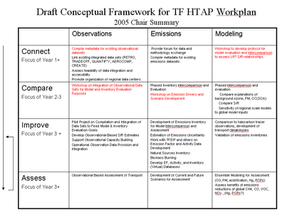
The focus of this wiki page is on the Information System that supposts Chapter 6: Integration of Observations, Emissions and Modeling.
Integration of Observations and Emissions
Identify providers and datasets relevant to HTAP
Homogenize the data into an interoperable dataset
Integrate multi-sensory data into a coherent data systems
Perform QA at all steps
Integration of Models
Step 1
Step 1
Step 1
Reconciliation and Integration of Observations, Emissions and Models
Compare observations to models and emissions
Characterize pollutant pattern and SSR
Develop real-time data assimilation
Perform reanalysis with assimilated data
Organizational Aspects
This is a place holder.
Major Adopt model evaluation/fusion as a design principle Challenge organizations to elevate transport as a primary objective (currently, secondary to climate, start. Ozone) Identify key list of routine measurements and locations to support IT assessments Gases (CO, NOy, NO2, SO2, HCHO, O3, Hg (species), CH4,VOCi) aerosol components (EC, OC, S, N), mass/scattering Support linkage of ground based and satellite observation platforms through development of a sustainable vertical profiling system (aircraft and ground based lidar) Address integration of disparate data bases QA/QC: provide requirements for data standards/metadata descriptions Data base unification
Design around major assessment tools
Air quality modeling platforms (GEOS-chem, MOZART, CMAQ,….more)
Satellite systems
Existing routine surface and aircraft programs
Emphasize
Model evaluation
Linkage of remote and land based systems
Integration of data information systems
Emphasis on limited set of key parameters [model evaluation, source apportionment, emissions perspective] Gases (CO, NOy, NO2?, SO2, HCHO?, O3, Hg?, CH4,VOCi?) aerosol components (C (EC, OC), S, N), mass/scattering Meteorological? Key locations, inflow and outflow perspective Standardization/QA Reference material, or method (aerosols) E.g.,GAW Aerosol Speciation Programme, GASP Data base, IT standards? Hemispherical data unification center? Practical LRTAP task? Organizational frameworks Build on IGACO-EMEP efforts Use guidance to influence participating nations
Goal: Advance air quality model-observation complex to level of meteorological FDDA systems
- Organizational frameworks linking observations and modeling…….help or hinder?.....LRTAP direction?
- GEOSS
- IGOS:IGACO
- GAW:GASP
- LRTAP
- list
- Satellite Systems
- List
- Routine measurement programs
- Ground based (List)
- NOAA CMDL, NASA
- Vertical profiling (aircraft, sondes, LIDAR)
Communal workspace for the subchapter on the HTAP information system framework and data integration
