Difference between revisions of "Statistics on Interoperability Papers at Fall AGU Meetings"
| Line 19: | Line 19: | ||
[[Image:InteropAGU2006_1.png|400px]]<br> | [[Image:InteropAGU2006_1.png|400px]]<br> | ||
| − | <small>Plot comes from: [http://capita.wustl.edu/capita/capitareports/061212FallAGU/Interop_Abstracs/Interop_Trends.xls Interoperability Trends]</small> | + | <small>Plot comes from: [http://capita.wustl.edu/capita/capitareports/061212FallAGU/Interop_Abstracs/Interop_Trends.xls Interoperability Trends Spreadsheet]</small> |
=== Application Areas and Target Users=== | === Application Areas and Target Users=== | ||
Half of the abstracts (11/21) pertain to''''' application areas''''' in Earth Science in general. While the other half is devoted to application that are targeted to either Earth Science subdomains (e.g. hydrology, ozone) or geographic (e.g. Antartica). | Half of the abstracts (11/21) pertain to''''' application areas''''' in Earth Science in general. While the other half is devoted to application that are targeted to either Earth Science subdomains (e.g. hydrology, ozone) or geographic (e.g. Antartica). | ||
[[Image:ApplicationDomain.png|300px]][[Image:TargetUsers.png|300px]]<br> | [[Image:ApplicationDomain.png|300px]][[Image:TargetUsers.png|300px]]<br> | ||
| − | <small>Plots come from: [http://capita.wustl.edu/capita/capitareports/061212FallAGU/Interop_Abstracs/061108Interop_Abstracts_Analysis.xls Interoperability Abstract Analysis]</small> | + | <small>Plots come from: [http://capita.wustl.edu/capita/capitareports/061212FallAGU/Interop_Abstracs/061108Interop_Abstracts_Analysis.xls Interoperability Abstract Analysis Spreadsheet]</small> |
The '''''target users''''' for the information systems were mostly for scientists (13/21). There are also significant efforts (5/21) devoted to public/educational users. Three papers on interoperability were "conceptual",e.g. data models, which makes them hard to classify.<br> | The '''''target users''''' for the information systems were mostly for scientists (13/21). There are also significant efforts (5/21) devoted to public/educational users. Three papers on interoperability were "conceptual",e.g. data models, which makes them hard to classify.<br> | ||
| Line 32: | Line 32: | ||
[[Image:DataAccessServices.png|300px]] [[Image:ServiceOperation.png|300px]]<br> | [[Image:DataAccessServices.png|300px]] [[Image:ServiceOperation.png|300px]]<br> | ||
| − | <small>Plots come from: [http://capita.wustl.edu/capita/capitareports/061212FallAGU/Interop_Abstracs/061108Interop_Abstracts_Analysis.xls Interoperability Abstract Analysis]</small> | + | <small>Plots come from: [http://capita.wustl.edu/capita/capitareports/061212FallAGU/Interop_Abstracs/061108Interop_Abstracts_Analysis.xls Interoperability Abstract Analysis Spreadsheet]</small> |
The data '''''service operations''''' were mostly data access services (15) and data discovery services (2). Four contributions are devoted to data processing and orchestration of service chains. Nine abstracts containing ''interoperability'' include end user tools such as data browsers, the rest did not.<br> | The data '''''service operations''''' were mostly data access services (15) and data discovery services (2). Four contributions are devoted to data processing and orchestration of service chains. Nine abstracts containing ''interoperability'' include end user tools such as data browsers, the rest did not.<br> | ||
Revision as of 16:05, November 8, 2006
Purpose and Procedure
The purpose of this note is to explore the current state of interoperability in information systems used in Earth Sciences. Since "interoperability" in Earth Sciences is applied in many different ways, we conducted an empirical evaluation of the current state based on the "interoperability" papers presented at the recent (2003-2006) meetings of the American Geophysical Union (AGU).
Wikipedia defines Interoperability as the ability of products, systems, or business processes to work together to accomplish a common task. According to ISO/IEC 2382-01, it is the "The capability to communicate, execute programs, or transfer data among various functional units in a manner that requires the user to have little or no knowledge of the unique characteristics of those units". [1]
In preparation for the AGU session: "Standards-Based Interoperability Among Tools and Data Services in the Earth Sciences" (Oral Session,Poster) we have performed a crude content analysis of submitted abstracts. It is not clear what purpose this excercise might have beyond informing the interested participants. The list of 21 analyzed abstracts mostly (18/21) includes contributions from the Earth Science Informatics domain. As seen below the classification of the contents is rather arbitrary.
The procedure for developing the statistics involve accessing the AGU Abstracts Database for the fall meetings of 2003, 2004, 2005, and 2006. The search was conducted using keywords that occurred in any of the abstract's fields including title, body, and keywords. Otherwise, the search was not confined, in other words the resulting list of abstracts was selected from the entire database for that year.
Context and Content of "Interoperability"
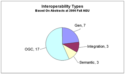
Searching for interoperability for the fall 2006 yielded thirty abstracts. Visual inspection of each abstract was performed to examine the context in which the interoperability was used. The pie chart below shows the number of abstracts for each context.
Of the thirty abstracts with interoperability, seven abstracts were classified as General since the context referred to general aspects of information interoperability. In three abstracts interoperability was used in the context of physical homogenization and integration of heterogeneous data. Another three abstracts dealt with the semantic aspect of interoperability, i.e. linking the meanings of different datasets. The largest group of seventeen abstracts incorporated interoperability with specific reference to appplications using the suite of OGC Standards.
It is evident that Earth Science interoperabilityis closely linked to the suite of OGC Standards. (Note: I think that I was some what biased toward OGC at the expense of semantic interoperability)
Plot comes from: Interoperability Trends Spreadsheet
Application Areas and Target Users
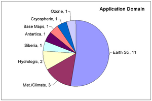
Half of the abstracts (11/21) pertain to application areas in Earth Science in general. While the other half is devoted to application that are targeted to either Earth Science subdomains (e.g. hydrology, ozone) or geographic (e.g. Antartica).
Plots come from: Interoperability Abstract Analysis Spreadsheet
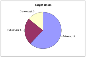
The target users for the information systems were mostly for scientists (13/21). There are also significant efforts (5/21) devoted to public/educational users. Three papers on interoperability were "conceptual",e.g. data models, which makes them hard to classify.
Data Services
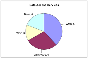
Data access services using WMS and WCS services are addressed in 17 of the abstracts. Eight abstracts indicated the use of WMS, three indicated the use of WCS Standards and six referrerd to both WMS and WCS.
Plots come from: Interoperability Abstract Analysis Spreadsheet
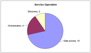
The data service operations were mostly data access services (15) and data discovery services (2). Four contributions are devoted to data processing and orchestration of service chains. Nine abstracts containing interoperability include end user tools such as data browsers, the rest did not.
Trends in use of Interoperability
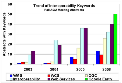
It is interesting to examine the four year trend of interoperability use in AGU abstracts. The procedure was to count the number of abstracts for search terms: interoperability, OGC, WMS, WCS, and "web services." The charts below show the trend of abstracts with these five terms.
Plots come from: Interoperability Trends Spreadsheet
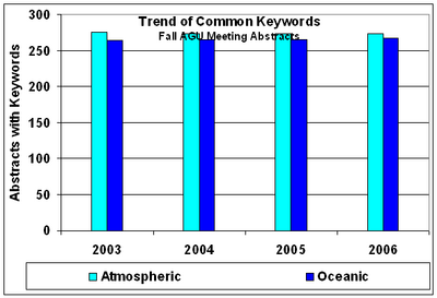
The number of abstracts with the terms interoperability and web services increased from 10-15 in 2003 to 35-40 in 2006. The frequency of abstracts with the terms OGC, WCS, and WMS have increased more dramatically. OGC increased from 2 to 25 while WMS and WCS increased rose from 2 to about 10 abstracts. The trend chart on the right shows the number of abstracts with "standard reference" terms: Atmospheric and Oceanic, each having about 250 abstracts per AGU meeting. This means that the overall number and mix of papers has not changed substantially in the 2003-2006 period.
Tentative Observations and Implications of the Anlaysis
From the above it may be observed that:
- The use of interoperability in abstracts has tripled between 2003 and 2006.
- In 2006, interoperability mainly refers to the application of OGC Standard Protocols.
- The OGC data access services, WMS and WCS are by far the most dominant.
A truly spectacular trend is seen for the use of Google Earth. In 2006, within a year of its appearance, there were fifty (50)! AGU abstracts referring to the use of Google Earth. What made Google Earth an instant hit? The cool appearance and user experience? Its openness and ease of mashing? Whatever is the cause, it clearly indicates that at times AGU scientists are willing and able to 'infuse' new technologies into their work in a blick.
It is meaningful to pursue the propogation of the WMS/WCS(WFS?) standards as the primary protocols for Earth Science data access.
It is hoped that the above provacative statements will promote constructive community discussion.
Rhusar 17:19, 7 November 2006 (EST)