Difference between revisions of "Obs Emiss Model Assimilation"
| Line 1: | Line 1: | ||
<center><big>Observation, Emission, Model Assimilation</big></center> | <center><big>Observation, Emission, Model Assimilation</big></center> | ||
| − | == | + | ==ObsEmissModel== |
[[Image:071124_ObsEmissModel.PNG|300px]] | [[Image:071124_ObsEmissModel.PNG|300px]] | ||
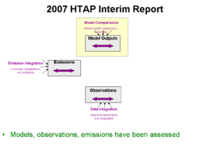
| + | The 2007 Interim Report [http://htap.org], the available HTAP-relevant global models, observations and emissions were assessed. The HTAP community has made particular contributions toward the intercomparison of global models. | ||
| − | == | + | ==OEM_Links== |
[[Image:071124_OEM_Links.PNG|300px]] | [[Image:071124_OEM_Links.PNG|300px]] | ||
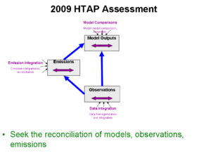
| + | The 2009 HTAP Assessment seeks to reconcile the models with observations and emissions. | ||
| − | == | + | ==OEM_LinkProc== |
[[Image:071124_OEM_LinkProc.PNG|300px]] | [[Image:071124_OEM_LinkProc.PNG|300px]] | ||
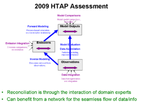
| + | This broader reconciliation will require the interaction of domain experts in all three areas, as well as the seamless flow of data among the participants. | ||
| + | A network that facilitates human-human as well as computer-computer interaction is desired. | ||
| − | == | + | ==OEM_Networking== |
[[Image:071124_OEM_Networking.PNG|300px]] | [[Image:071124_OEM_Networking.PNG|300px]] | ||
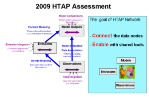
| + | The main goal of the HTAP network is to facilitate the human and data connectivity. Given the connectivity, we wish to enable the participants with shared tools and methods. | ||
| − | == | + | ==OMINO2_Avg== |
[[Image:071124_OMINO2_Avg.PNG|300px]] | [[Image:071124_OMINO2_Avg.PNG|300px]] | ||
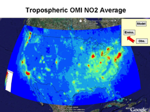
| + | It is now possible to develop a chemical climatology (2004-7) of tropospheric NO2 based on routine daily satellite observations. The data show a highly patchy pattern over the Contiental US. | ||
| + | Such data can aid the understanding of NO2 sources, atmospheric dynamics and potential impacts on human health and welfare. | ||
| − | == | + | ==OMINO2_Mobile== |
[[Image:071124_OMINO2_Mobile.PNG|300px]] | [[Image:071124_OMINO2_Mobile.PNG|300px]] | ||
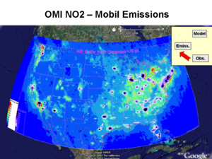
| + | Superposition of mobile emission sources on the climatotlogical OMI NO2 shows that most of the observed NO2 hotspots are indeed over metropolitan areas where automotive emissions of NOxare domiant. | ||
| − | == | + | ==OMINO2_Point== |
[[Image:071124_OMINO2_Point.PNG|300px]] | [[Image:071124_OMINO2_Point.PNG|300px]] | ||
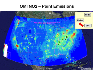
| + | A broader elevated tropospheric NO2 is observed over the Ohio River valley, where a string of power plants are responsible for significant NOx emissions. | ||
| + | However, additional hotspots are also observed over known individual power plants in the western and southeastern US. | ||
| − | == | + | ==OMINO2_PointWest== |
[[Image:071124_OMINO2_PointWest.PNG|300px]] | [[Image:071124_OMINO2_PointWest.PNG|300px]] | ||
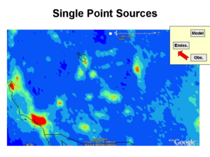
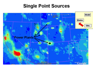
| + | In the Western US, individual power plants, most notable the Four Corners plant, are clearly discernable by impact on their surroundings | ||
| − | == | + | ==OMINO2_PointWestPoint== |
[[Image:071124_OMINO2_PointWestPoint.PNG|300px]] | [[Image:071124_OMINO2_PointWestPoint.PNG|300px]] | ||
| − | == | + | ==OMINO2_GASmokeAvg== |
[[Image:071124_OMINO2_GASmokeAvg.PNG|300px]] | [[Image:071124_OMINO2_GASmokeAvg.PNG|300px]] | ||
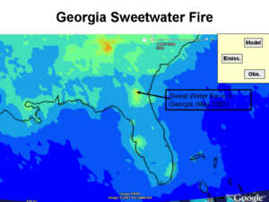
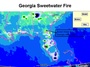
| + | Non-industrial sources of NOx are also detectable in the OMI NO2 climatology. The impact of the S. Georgia fire in May 2007 is clearly quantifyable. | ||
| − | == | + | ==OMINO2_GASmokeMobil== |
[[Image:071124_OMINO2_GASmokeMobil.PNG|300px]] | [[Image:071124_OMINO2_GASmokeMobil.PNG|300px]] | ||
| + | It is evident, that the fire emission can be spatially separated from the urban and power plant emissions. | ||
| − | == | + | ==OMINO2_IdahoSmoke== |
[[Image:071124_OMINO2_IdahoSmoke.PNG|300px]] | [[Image:071124_OMINO2_IdahoSmoke.PNG|300px]] | ||
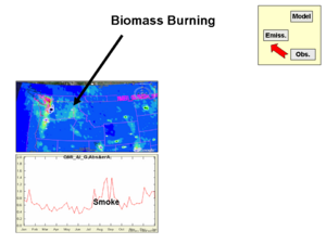
| + | The regular biomass burning in the Northwestern US has also quantifiable impact on the tropospheric NO2. Such data can be evaluated to generate improved emission inventories for NOx. | ||
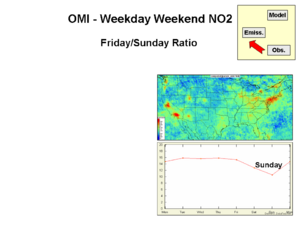
| − | == | + | The daily time resolution of the OMI NO2 data allows the quantification of the weekday-weekend effect. For example, in large metropolitan areas, the Friday NO2 exceeds the Sunday values by a factor of 1.2-1.4. This again can aid the development of higher time resolution emission inventories for NOx. |
| + | |||
| + | ==OMINO2_WeekdayWeekend== | ||
[[Image:071124_OMINO2_WeekdayWeekend.PNG|300px]] | [[Image:071124_OMINO2_WeekdayWeekend.PNG|300px]] | ||
| + | !!!Wrong Image!!! | ||
| + | ==OMINO2_OhioNewYork== | ||
| + | [[Image:071124_OMINO2_OhioNewYork.PNG|300px]] | ||
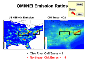
| + | However, there are also significant questions to be explored. | ||
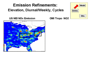
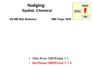
| − | + | Why is the OMI NO2/EPA Emission ratio 40% higher over the Eastern megalopolis than over the Ohio River Valley? | |
| − | |||
| − | == | + | ==OMINO2_Emission_Model_Link== |
[[Image:071124_OMINO2_Emission_Model_Link.PNG|300px]] | [[Image:071124_OMINO2_Emission_Model_Link.PNG|300px]] | ||
| + | However, there are also significant questions to be explored. | ||
| − | == | + | Why is the OMI NO2/EPA Emission ratio 40% higher over the Eastern megalopolis than over the Ohio River Valley? |
| + | |||
| + | ==OMINO2_NudgingExample== | ||
[[Image:071124_OMINO2_NudgingExample.PNG|300px]] | [[Image:071124_OMINO2_NudgingExample.PNG|300px]] | ||
| + | However, there are also significant questions to be explored. | ||
| + | |||
| + | Why is the OMI NO2/EPA Emission ratio 40% higher over the Eastern megalopolis than over the Ohio River Valley? | ||
| − | == | + | ==OMINO2_TropoStratoSeparation== |
[[Image:071124_OMINO2_TropoStratoSeparation.PNG|300px]] | [[Image:071124_OMINO2_TropoStratoSeparation.PNG|300px]] | ||
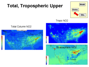
| + | Also, why does the Stratospheric NO2 from OMI exhibit ‘NO2 holes’ over the major Easter cities in some of the months? | ||
| + | Is the Total NO2 column split properly between the troposphere and stratosphere? | ||
| − | == | + | ==OMINO2_GlobalOMIModelMap== |
[[Image:071124_OMINO2_GlobalOMIModelMap.PNG|300px]] | [[Image:071124_OMINO2_GlobalOMIModelMap.PNG|300px]] | ||
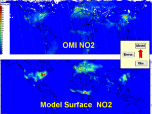
| + | The available OMI NO2 data and the results of NO2 models will allow a global-scale comparison. | ||
| + | This new opportunity will permit the global-scale reconciliation of the models-emissions and observations. | ||
| − | == | + | ==OMINO2_SurfOMIModelTime== |
[[Image:071124_OMINO2_SurfOMIModelTime.PNG|300px]] | [[Image:071124_OMINO2_SurfOMIModelTime.PNG|300px]] | ||
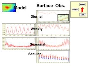
| + | Model Observation comparison: Temporal pattern | ||
Revision as of 21:13, November 24, 2007
ObsEmissModel
OEM_Links
OEM_LinkProc
OEM_Networking
OMINO2_Avg
OMINO2_Mobile
OMINO2_Point
OMINO2_PointWest
OMINO2_PointWestPoint
OMINO2_GASmokeAvg
OMINO2_GASmokeMobil
OMINO2_IdahoSmoke
The daily time resolution of the OMI NO2 data allows the quantification of the weekday-weekend effect. For example, in large metropolitan areas, the Friday NO2 exceeds the Sunday values by a factor of 1.2-1.4. This again can aid the development of higher time resolution emission inventories for NOx.
OMINO2_WeekdayWeekend
OMINO2_OhioNewYork
Why is the OMI NO2/EPA Emission ratio 40% higher over the Eastern megalopolis than over the Ohio River Valley?
OMINO2_Emission_Model_Link
Why is the OMI NO2/EPA Emission ratio 40% higher over the Eastern megalopolis than over the Ohio River Valley?
OMINO2_NudgingExample
Why is the OMI NO2/EPA Emission ratio 40% higher over the Eastern megalopolis than over the Ohio River Valley?
OMINO2_TropoStratoSeparation
OMINO2_GlobalOMIModelMap
