Difference between revisions of "HTAP Report, Sub-Chap. 6 - Data/Info System"
| Line 71: | Line 71: | ||
===HTAP Relationship to IGACO=== | ===HTAP Relationship to IGACO=== | ||
| − | [[Image:IGACO Framework.png|300px|left]] The HTAP program can also have a mutually beneficial interaction with the IGACO program. Integrated Global Atmospheric Chemistry Observations (IGACO) | + | [[Image:IGACO Framework.png|300px|left]] The HTAP program can also have a mutually beneficial interaction with the IGACO program. Integrated Global Atmospheric Chemistry Observations (IGACO) Theme is part of the Integrated Global Observing Strategy (IGOS). The IGACO program is formulated by an array of experienced atmospheric scientists. IGACO proposes a specific framework for the system components that processes the observational data and models. It also specifies the higher level information products that can be used for creating social benefit. |
| − | In the IGACO framework the data products from | + | In the IGACO framework, the data products from satellite, surface, and aircraft observations are collected for inclusion into an integrated data archive. A key component in the IGACO data flow is the mandatory quality assurance and QA QC that precedes the archiving. This is particularly important for HTAP where multi-sensory data from many different providers are to be combined into an integrated database. In the IGACO framework, a key output from the data system is a high integrated spatial-temporal data set which can be used in a multitude of applications that produce socal benefit. The goal of creating such an integrated data set is shared by the IGACO and the HTAP programs (?? Len, this section could benefit from your input) |
| − | |||
| − | |||
===HTAP Relationship with Other Programs=== | ===HTAP Relationship with Other Programs=== | ||
Revision as of 20:46, April 9, 2007
< Back to Integrated Global Dataset on ESIP wiki
Fragments for Chapter 6. Integration of Observations, Emissions and Modeling
This wiki page is inteded to be the collaborative workspace for Task Force members interested in the HTAP Information System development, implementation and use. The contents can be freely edited by anyone who is logged in. Comments and feedback can also be sent by email to rhusar@me.wustl.edu. The content of this page is is on the Information System that supposts Chapter 6. The subsections are action-oriented.
From Oct 2006 Prospectus: This chapter (Chapter 6: Integration of Observations, Emissions and Modeling.) will discuss the need to integrate information from observations, models, and emissions inventories to better understand intercontinental transport. A draft HTAP Report Chap. 6 - Jan 07 Outline is also on this wiki.
Integration of Observations and Emissions
A key early recommendation was to emphasize the integration of current and emerging data/information systems. The ultimate goal of that data system is to assemble for HTAP an appropriate set of observations, with known quality and representativeness, and to facilitate the integration and fusion of observations with models.
Sensing revolution.. from dataFed paper
Data Selection Criteria
Monitoring data for atmospheric constituents are now available from a variety of sources, not all of which are suitable for the integrated HTAP data set. Given the limited scope and resources of HTAP, it will be necessary to select a subset of the available observational data that would be most appropriate for the preparation of the 2009 assessment. A set of criteria for the data selection is given below.
- The suitability criteria may include the measured parameters, their spatial extent and coverage density, as well as the time range and sampling frequency with major emphasis on data quality (defined as???).
- The compilation of the global integrated data sets should initially focus on PM and ozone, including the gaseous precursors.
- Subsequent data collaction should also include observations on atmospheric mercury and persistent organic pollutants (POPS).
- In order to cover hemispheric transport of air pollutants the data set system should accept and utilize data from outside the geographical scope of EMEP.
- The data gathering should begin the compilation using the of existing databases in Europe (RETRO, TRADEOFF, QUANTIFY, CRATE, AEROCOM) and virtual federated systems in the US (DataFed, Giovanni and others).
- TF data integration should also contribute to and benefit from other ongoing data integration efforts to integrate the global data resources, most notably, with ACCENT project in Europe, and similar efforts in the US.
- Special emphasis should be placed on the collection of suitable vertical profiles from aircraft measurements as well as from surface and space-borne lidars.
The evaluation of suitabile observational data sets for model validation and fusion will require close interaction between the modeling and observational communities. An wiki workspace for open collaborative evaluation of different datasets is desirebale.
Interoperability Standards for HTAP Integration
- Parameter Naming: CF Naming Concention for Chemicals - Textor
- Data format: netCDF CF and others
- Data Access: OGC Web Coverage Service, WCS Galeon
Homogenize the data into an interoperable dataset
Identify providers and datasets relevant to HTAP
Integrate multi-sensory data into a coherent data systems
In order to accomplish the objectives set for the HTAP TF it is evident that it will require the System of Systems approach as envisioned by GEO. Both the modeling of the chemical constituents as well as the Earth observations used to document the hemispheric transport are being performed by individual autonomous projects and programs (Systems). A key function of the Task Force is to assess the contributions of the individual systems and then integrate those into a coherent assessment. Much of this interim report is in fact such an assessment of the current knowledge based on previous or past models and observations.
In the next, upcoming phase of HTAP is to actually integrate the existing modeling and observing systems such that their combination and fusion can yield a deeper and more robust understanding of HTAP. since this next phase will involve integration of multiple relevant data sets, comparison and evaluation of multiple models, as well as the reconciliation of the observations and models to create the new and deeper understanding . In order to execute this extensive integration, it will be necessary to conduct this integration using a generally accepted framework as well as accepted scientific methods. It is believed that the GEO architecture and the System of Systems is an attractive approach to HTAP integration.
The HTAP program can also be considered an early demonstration of the GEO concepts through its end to end approach. Both the atmospheric modeling, as well as the observations currently exist through the operation of existing modeling and observation systems. The Task Force has agreed organizing and evaluating those models, assembling and integrating the observational data sets and then reconciling the models with the observations will be the focus of the Phase II effort. The Task Force will also prepare and deliver a report to LRTP to aid its deliberations and its decision making processes. This sequence of activities constitutes an end to end approach that turns observations and models into actionable knowledge for societal decision making. One could say that this is an octagonal approach to more deliberate step by step development of GEOSS where in Phase I interoperability, in Phase II ???
Provider nodes
- Federated Data System DataFed
- NASA Data System Giovanni
- Emission Data System NEISGEI
- Juelich Data System
- AeorCom
- EMEP
Data Networks. Connected hubs; Show Core HTAP network
See 20 selected datasets in the federated data systems, DataFed
Perform QA at all steps
Reconciliation and Integration of Observations, Emissions and Models
Compare observations to models and emissions
Characterize pollutant pattern and SSR
Develop real-time data assimilation
Perform reanalysis with assimilated data
Organizational Aspects
HTAP Relationship to GEO and GEOSS
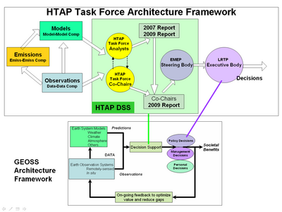
There is an outstanding opportunity to develop a mutually beneficial and supportive relationship between the activities of the HTAP Task Force and that of GEO. The Group of Earth Observations with its broad range of national and organizational members has developed a general architectural framework for turning Earth observations into societal benefits. The three main components of this architecture are models, and observations, which then feed into decision support systems used in a variety of societal decision making. This general framework is well suited as an architectural guide to the HTAP program. However, this framework lacks specific guidelines and implementation details that are needed for practical Earth observing and decision support systems.
The HTAP program provides an opportunity to extend the GEO framework with more detailed features that arise in specific HTAP application context. In case of HTAP, the major activities are shown in the architectural diagram of Figure ?? The HTAP modeling is conducted through global scale chemical transport models that simulate or forecast the atmospheric chemical composition as a consequence of natural and human induced emissions. The observations arise from satellite, ground-based and airborne observations of chemical constituents and their hemispheric transport. The decision support system consists of the scientists as members of the HTAP task force, and the task force co-chairs as the intermediaries between LRTP and the TF. (Terry, Andre this description of the HTAP DSS needs your help).
Representing the Decision Support System (DSS) for HTAP is an important aspect because it can guide the design and and implementation of the information system for the support of the DSS processes. A higher resolution DSS design document is also beneficial as a communications medium for the interacting system of systems. A domain specific DSS may also allow the generalization and applicability to the design of DSS structures for similar application domains.
The implementation of the GEO framework utilizes the concept of Global Observing System of Systems (GEOSS). Traditionally, Earth observations were performed by well defined systems such as specific satellites and monitoring networks which were designed and operated using systems engineering principles. However, GEO recognized that the understanding of Earth system requires the utilization and integration of the individual, autonomous systems. The key difference between the Systems and System of System approaches are highlighted in Table 1.
HTAP Relationship to IGACO
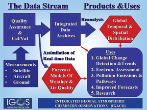
The HTAP program can also have a mutually beneficial interaction with the IGACO program. Integrated Global Atmospheric Chemistry Observations (IGACO) Theme is part of the Integrated Global Observing Strategy (IGOS). The IGACO program is formulated by an array of experienced atmospheric scientists. IGACO proposes a specific framework for the system components that processes the observational data and models. It also specifies the higher level information products that can be used for creating social benefit.
In the IGACO framework, the data products from satellite, surface, and aircraft observations are collected for inclusion into an integrated data archive. A key component in the IGACO data flow is the mandatory quality assurance and QA QC that precedes the archiving. This is particularly important for HTAP where multi-sensory data from many different providers are to be combined into an integrated database. In the IGACO framework, a key output from the data system is a high integrated spatial-temporal data set which can be used in a multitude of applications that produce socal benefit. The goal of creating such an integrated data set is shared by the IGACO and the HTAP programs (?? Len, this section could benefit from your input)
HTAP Relationship with Other Programs
--- ---

