File:OD550 AER an2000 mALLYEAR WORLD MAP.ps.png
From Earth Science Information Partners (ESIP)
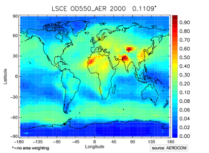
Revision as of 08:52, January 8, 2010 by Jan Griesfeller (Griesfel) (talk | contribs) (Plot of optical depth at 550nm. Example file for a plot of a standard AEROCOM catalogue.)
No higher resolution available.
OD550_AER_an2000_mALLYEAR_WORLD_MAP.ps.png (412 × 302 pixels, file size: 377 KB, MIME type: image/png)
Plot of optical depth at 550nm. Example file for a plot of a standard AEROCOM catalogue.
File history
Click on a date/time to view the file as it appeared at that time.
| Date/Time | Thumbnail | Dimensions | User | Comment | |
|---|---|---|---|---|---|
| current | 08:52, January 8, 2010 | | 412 × 302 (377 KB) | Jan Griesfeller (Griesfel) (talk | contribs) | Plot of optical depth at 550nm. Example file for a plot of a standard AEROCOM catalogue. |
You cannot overwrite this file.
File usage
The following 2 pages use this file: