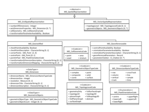
MD VectorSpatialRepresentation
From Earth Science Information Partners (ESIP)
Revision as of 07:55, October 30, 2018 by Nathan.wilson (talk | contribs) (→msr:MD_VectorSpatialRepresentation)
msr:MD_VectorSpatialRepresentation
| Elements | Domain | Definition and Recommended Practice | Examples | ||
|---|---|---|---|---|---|
| 1 | msr:scope | 0..1 | mcc:MD_Scope | Level and extent of the spatial representation | |
| 2 | msr:topologyLevel | 0..1 | msr:MD_TopologyLevelCode | Code which identifies the degree of complexity of the spatial relationships | |
| 3 | msr:geometricObjects | 0..* | msr:MD_GeometricObjects | Information about the geometric objects used in the resource | |


