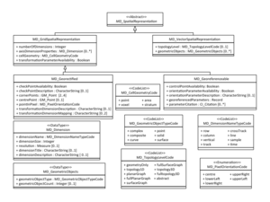
MD Georeferenceable
From Earth Science Information Partners (ESIP)
Revision as of 08:22, October 23, 2018 by Nathan.wilson (talk | contribs) (→msr:MI_Georeferenceable)
msr:MD_Georeferenceable
Use msr:MI_Georeferenceable if utilizing Imagery extensions
| Elements | Domain | Definition and Recommended Practice | Examples | ||
|---|---|---|---|---|---|
| 1 | msr:numberOfDimensions | 1 | gco:Integer | Number of independent spatial-temporal axes | |
| 2 | msr:axisDimensionProperties | 0..* | msr:MD_Dimension | Information about spatial-temporal axis properties | |
| 3 | msr:cellGeometry | 1 | msr:MD_CellGeometryCode | Identification of grid data as point or cell | |
| 4 | msr:transformationParameterAvailability | 1 | gco:Boolean | Indication of whether or not parameters for transformation between image coordinates and geographic or map coordinates exist (are available) | |
| 5 | msr:controlPointAvailability | 1 | gco:Boolean | Indication of control point existence | |
| 6 | msr:orientationParameterAvailability | 1 | gco:Boolean | Indication of orientation parameters availability | |
| 7 | msr:orientationParameterDescription | 0..1 | gco:CharacterString | Description of parameters used to describe sensor orientation | |
| 8 | msr:georeferencedParameters | 1 | gco:Record | Terms which support grid data georeferencing | |
| 9 | msr:parameterCitation | 0..* | cit:CI_Citation | Citation for the parameter reference | |
msr:MI_Georeferenceable
Use msr:MD_Georeferenceable if not utilizing Imagery extensions
| Elements | Domain | Definition and Recommended Practice | Examples | ||
|---|---|---|---|---|---|
| 1 | msr:numberOfDimensions | 1 | gco:Integer | Number of independent spatial-temporal axes | |
| 2 | msr:axisDimensionProperties | 0..* | msr:MD_Dimension | Information about spatial-temporal axis properties | |
| 3 | msr:cellGeometry | 1 | msr:MD_CellGeometryCode | Identification of grid data as point or cell | |
| 4 | msr:transformationParameterAvailability | 1 | gco:Boolean | Indication of whether or not parameters for transformation between image coordinates and geographic or map coordinates exist (are available) | |
| 5 | msr:controlPointAvailability | 1 | gco:Boolean | Indication of control point existence | |
| 6 | msr:orientationParameterAvailability | 1 | gco:Boolean | Indication of orientation parameters availability | |
| 7 | msr:orientationParameterDescription | 0..1 | gco:CharacterString | Description of parameters used to describe sensor orientation | |
| 8 | msr:georeferencedParameters | 1 | gco:Record | Terms which support grid data georeferencing | |
| 9 | msr:parameterCitation | 0..* | cit:CI_Citation | Citation for the parameter reference | |
| 10 | msr:platformParameters | 0..1 | mac:MI_Platform | ||
| 11 | msr:geolocationInformation | 1..* | msr:MI_GCPCollection | Information that can be used to geolocate the data | |


