Difference between revisions of "MD GridSpatialRepresentation"
From Earth Science Information Partners (ESIP)
m (1 revision: Importing the ISO Explorer Category from GEO-IDE Wiki (Ted Habermann)) |
|||
| Line 1: | Line 1: | ||
[[File:MD_SpatialRepresentation.png|thumb|top|right]] | [[File:MD_SpatialRepresentation.png|thumb|top|right]] | ||
| − | <table> | + | |
| + | |||
| + | |||
| + | |||
| + | |||
| + | |||
| + | |||
| + | |||
| + | |||
| + | |||
| + | |||
| + | |||
| + | |||
| + | |||
| + | <div id="elementsAndDefinitions"> | ||
| + | <!--elements, definitions, and examples for class: MD_GridSpatialRepresentation--> | ||
| + | <table cellpadding="3" width="100%"> | ||
<tr> | <tr> | ||
| − | + | <th colspan="3">Elements</th> | |
| − | + | <th><i>Definition and Recommended Practice</i></th> | |
| − | + | <th><pre>Examples</pre></th> | |
| − | + | </tr> | |
| − | + | <tr> | |
| − | + | <td bgcolor="FFFF99">1</td> | |
| − | + | <td bgcolor="FFFF99">[[Integer|numberOfDimensions]]</td> | |
| − | + | <td bgcolor="FFFF99">1</td> | |
| − | + | <td><i>number of independent spatial-temporal axes</i></td> | |
| − | + | <td><pre>Example is needed</pre></td> | |
| − | + | </tr> | |
| − | + | <tr> | |
| − | + | <td bgcolor="CCFFFF">2</td> | |
| − | + | <td bgcolor="CCFFFF">[[MD_Dimension|axisDimensionProperties]]</td> | |
| − | + | <td bgcolor="CCFFFF">0..*</td> | |
| − | + | <td><i>information about spatial-temporal axis properties</i></td> | |
| − | + | <td><pre>Example is needed</pre></td> | |
| − | + | </tr> | |
| − | + | <tr> | |
| − | + | <td bgcolor="FFFF99">3</td> | |
| − | + | <td bgcolor="FFFF99">[[ISO_19115_and_19115-2_CodeList_Dictionaries#MD_CellGeometryCode|cellGeometry]]</td> | |
| − | + | <td bgcolor="FFFF99">1</td> | |
| − | + | <td><i>identification of grid data as point or cell</i></td> | |
| − | + | <td><pre>Example is needed</pre></td> | |
| − | + | </tr> | |
| − | + | <tr> | |
| − | + | <td bgcolor="FFFF99">4</td> | |
| − | </table> | + | <td bgcolor="FFFF99">[[Boolean|transformationParameterAvailability]]</td> |
| − | OR | + | <td bgcolor="FFFF99">1</td> |
| − | + | <td><i>indication of whether or not parameters for transformation between image coordinates | |
| + | and geographic or map coordinates exist (are available)</i></td> | ||
| + | <td><pre>Example is needed</pre></td> | ||
| + | </tr> | ||
| + | </table> | ||
| + | </div> | ||
| + | |||
| + | OR | ||
<table cellpadding="3"> | <table cellpadding="3"> | ||
<tr> | <tr> | ||
Revision as of 17:13, December 8, 2016
| Elements | Definition and Recommended Practice | Examples |
||
|---|---|---|---|---|
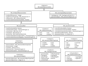
| 1 | numberOfDimensions | 1 | number of independent spatial-temporal axes | Example is needed |
| 2 | axisDimensionProperties | 0..* | information about spatial-temporal axis properties | Example is needed |
| 3 | cellGeometry | 1 | identification of grid data as point or cell | Example is needed |
| 4 | transformationParameterAvailability | 1 | indication of whether or not parameters for transformation between image coordinates and geographic or map coordinates exist (are available) | Example is needed |
OR
| MD_Georeferenceable / MI_Georeferenceable |
|---|
OR
| MD_Georectified / MI_Georectified |
|---|
Please contribute!
- transformationParameterAvailability
- indication of whether or not parameters for transformation between image coordinates and geographic or map coordinates exist (are available).
- Plain English
- Select yes, if the map coordinates are available in the file headers or related dataset documentation have enough information to re-project the data.


