Difference between revisions of "MI Objective"
From Earth Science Information Partners (ESIP)
| (One intermediate revision by the same user not shown) | |||
| Line 30: | Line 30: | ||
<tr> | <tr> | ||
<td bgcolor="CCFFFF">3</td> | <td bgcolor="CCFFFF">3</td> | ||
| − | <td bgcolor="CCFFFF">[[ | + | <td bgcolor="CCFFFF">[[ISO_19115-3_Codelists#MI_ObjectiveTypeCode|mac:type]]</td> |
<td bgcolor="CCFFFF">0..*</td> | <td bgcolor="CCFFFF">0..*</td> | ||
| − | <td bgcolor="CCFFFF">[[ | + | <td bgcolor="CCFFFF">[[ISO_19115-3_Codelists#MI_ObjectiveTypeCode|mac:MI_ObjectiveTypeCode]]</td> |
<td>Collection technique for the objective</td> | <td>Collection technique for the objective</td> | ||
<td><i></i></td> | <td><i></i></td> | ||
Latest revision as of 06:30, September 12, 2017
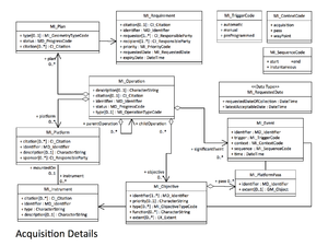
mac:MI_Objective
Describes the characteristics, spatial and temportal extent of the intended object to be observed
| Elements | Domain | Definition and Recommended Practice | Examples | ||
|---|---|---|---|---|---|
| 1 | mac:identifier | 1..* | mcc:MD_Identifier | Registered code used to identify the objective | |
| 2 | mac:priority | 0..1 | gco:CharacterString | priority applied to the target | |
| 3 | mac:type | 0..* | mac:MI_ObjectiveTypeCode | Collection technique for the objective | |
| 4 | mac:function | 0..* | gco:CharacterString | Function performed by or at the objective | MI_Objective
|
| 5 | mac:extent | 0..* | gex:EX_Extent | Extent information including the bounding box, bounding polygon, vertical and temporal extent of the objective | |
| 6 | mac:sensingInstrument | 0..* | mac:MI_Instrument | Instrument which sensed the objective data | |
| 7 | mac:pass | 0..* | mac:MI_PlatformPass | Pass of the platform over the objective | |
| 8 | mac:objectiveOccurence | 1..* | mac:MI_Event | event or events associated with objective completion. | |


