Difference between revisions of "NOAA HMS WFS"
| Line 32: | Line 32: | ||
* [http://technorati.com/search/AirNow+AND+EPA Technorati Blogs] - AirNOW + EPA | * [http://technorati.com/search/AirNow+AND+EPA Technorati Blogs] - AirNOW + EPA | ||
* [http://del.icio.us/search/?fr=del_icio_us&p=AIRNOW&type=all Del.icio.us ] - AIRNOW | * [http://del.icio.us/search/?fr=del_icio_us&p=AIRNOW&type=all Del.icio.us ] - AIRNOW | ||
| − | + | {{Addition Dataset Information}} | |
[[Category:NearRealTime]] | [[Category:NearRealTime]] | ||
Revision as of 17:08, January 7, 2008
NOAA_HMS_WFS - Dataset Title
 |
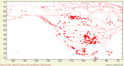
Description: Fires are recorded by MODIS and other satellite sensors and reported through NOAA HMS as red pixels. Parameters: AVHRR, MODIS, HMS, GOES |
- Browse Fields
- RDF for NOAA_HMS_WFS <- Should be a property
- What Links here on ESIP wiki
- 400px
User-provided Metadata
NOAA_HMS_WFS FAQ's
Lineage
Websites
Websites tagged in Del.icio.us with: NOAA_HMS_WFS Link <feed showtitle=false>http://del.icio.us/rss/tag/NOAA_HMS_WFS+Link</feed>
Papers
Papers tagged in Del.icio.us with: dataset NOAA_HMS_WFS Paper <feed showtitle=false>http://del.icio.us/rss/tag/NOAA_HMS_WFS+dataset+Paper</feed>
Automatic Searches
- Google Search | Blogs | Scholar | Images | News | Video - AirNOW + EPA
- Technorati Blogs - AirNOW + EPA
- Del.icio.us - AIRNOW
