< Back to DataSpaces
MODISm_G - Dataset Title
Viewers:  | | 
|
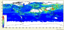
Description: Giovanni MODIS Online Visualization and Analysis System (MOVAS) Parameters: No Parameters Given
Domain: Aerosol |
Platform: Satellite | Instrument: No Instrument |
Method: RemoteSens |
Type: GRID | Periodicity: No Periodicity"No Periodicity" is not in the list (HOUR, HALF_HOUR, SIX_HOURS, DAY, WEEK, MONTH, YEAR, FIVE_YEARS, NONE) of allowed values for the "Periodicity" property. | GeoRange: No GeoRange"No GeoRange" is not in the list (NAM, US, EUR, GLOB, SEASIA, SAM, SWASIA, AFRICA) of allowed values for the "GeoRange" property. | Time Period: No TimePeriod"No TimePeriod" is not in the list (REALTIME, HIST, FORECAST) of allowed values for the "TimePeriod" property.
Key Use: No Key Uses
Data Access Services: WMS | WCS
|
|
NASA

Provider
No Distributor
Source
Citation
Lineage
|
User-Contributioned Resources. See also discussion page. Help on Edit.
Dataset Description
Data description here
Related Links
Additional Information
Edit MODISm_G-RDF | View MODISm_G-RDF
