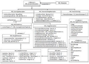
MI ImageDescription
From Earth Science Information Partners (ESIP)
The printable version is no longer supported and may have rendering errors. Please update your browser bookmarks and please use the default browser print function instead.
| Elements | Definition and Recommended Practice | Examples | ||
|---|---|---|---|---|
| 1 | illuminationElevationAngle | 0..* | Illumination elevation measured in degrees clockwise from the target plane at intersection of the optical line of sight with the Earth's surface. For images from a scanning device, refer to the centre pixel of the image. | Example is needed |
| 2 | illuminationAzimuthAngle | 0..* | Illumination azimuth measured in degrees clockwise from true north at the time the image is taken. For images from a scanning device, refer to the centre pixel of the image. | Example is needed |
| 3 | imagingCondition | 0..* | Conditions affected the image. | Example is needed |
| 4 | imageQualityCode | 0..* | Code in producers code space that specifies the image quality. | Example is needed |
| 5 | cloudCoverPercentage | 0..* | Area of the dataset obscured by clouds, expressed as a percentage of the spatial extent. | Example is needed |
| 6 | compressionGenerationQuantity | 0..* | Count of the number of lossy compression cycles performed on the image. | Example is needed |
| 7 | triangulationIndicator | 0..* | Indication of whether or not triangulation has been upon the image. | Example is needed |
| 8 | radiometricCalibrationDataAvailability | 0..* | Indication of whether or not the radiometric calibration information for generating the radiometrically calibrated standard data product is available. | Example is needed |
| 9 | cameraCalibrationInformationAvailability | 0..* | Indication of whether or not constants are available which allow for camera calibration corrections. | Example is needed |
| 10 | filmDistortionInformationAvailability | 0..* | Indication of whether or not Calibration Reseau information is available. | Example is needed |
| 11 | lensDistortionInformationAvailability | 0..* | Indication of whether or not lens aberration correction information is available. | Example is needed |


