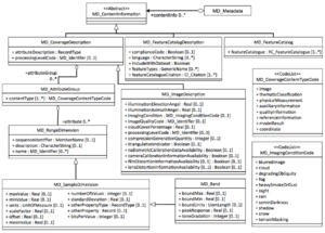
MI ImageDescription
From Earth Science Information Partners (ESIP)
Revision as of 10:32, October 25, 2016 by Ted.Habermann (talk | contribs) (1 revision: Importing the ISO Explorer Category from GEO-IDE Wiki (Ted Habermann))
The printable version is no longer supported and may have rendering errors. Please update your browser bookmarks and please use the default browser print function instead.
MI_ImageDescription extends MD_ImageDescription.
| Elements | Definition and Recommended Practice | Examples |
||
|---|---|---|---|---|
| 1 | attributeDescription | 1 | General description of the attributes listed in dimension or range. Keep brief. | |
| 2 | contentType | 1 | Classification of attributes. Most common code values are 'thematicClassification' or 'physicalMeasurement'. | physicalMeasurement |
| 3 | dimension | 0..* | Information about attributes that have a measured value. Recommend providing attribute name, minimum value, maximum value and units. | |
| 4 | illuminationElevationAngle | 0..1 | ||
| 5 | illuminationAzimuthAngle | 0..1 | ||
| 6 | imagingCondition | 0..1 | ||
| 7 | imageQualityCode | 0..1 | ||
| 8 | cloudCoverPercentage | 0..1 | ||
| 9 | processingLevelCode | 0..1 | ||
| 10 | compressionGenerationQuantity | 0..1 | ||
| 11 | triangulationIndicator | 0..1 | ||
| 12 | radiometricCalibrationDataAvailability | 0..1 | ||
| 13 | cameraCalibrationInformationAvailability | 0..1 | ||
| 14 | filmDistortionInformationAvailability | 0..1 | ||
| 15 | lensDistortionInformationAvailability | 0..1 | ||
| 4 | rangeElementDescription | 0..* | Information about attributes that have enumerative values. Provide name, definition and list of values. | |


