Difference between revisions of "GEO AQ CoP"
From Earth Science Information Partners (ESIP)
| Line 35: | Line 35: | ||
[[GEO_AQ_Community_of_Practice:_Role,_Mission,_Objectives|CoP General]] | [[GEO_AQ_Community_of_Practice:_Role,_Mission,_Objectives|CoP General]] | ||
|bgcolor="#FFFFFF" style="border: 1px solid gray;padding-left:0.5em;padding-right:0.5em;" width="50%"| | |bgcolor="#FFFFFF" style="border: 1px solid gray;padding-left:0.5em;padding-right:0.5em;" width="50%"| | ||
| − | === <center>Resources </center>=== | + | === <center>Tools and Resources </center>=== |
[[Image:AQCoPDataModel.png|thumb|100px]] | [[Image:AQCoPDataModel.png|thumb|100px]] | ||
* [[GEO AQ CoP Tools and Methods|Tools and Methods]] | * [[GEO AQ CoP Tools and Methods|Tools and Methods]] | ||
Revision as of 14:47, April 26, 2012

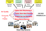
The GEO AQ CoP is a self-organized voluntary group that fosters the application of Earth observations to air quality management and science. Its participants and its main beneficiaries are members of national and international science teams, data portals and decision support activities. CoP activities include sharing tools and best practices and facilitation of standards-based networking of air quality data systems using GEOSS data sharing principles.
|
|
|
|

