Difference between revisions of "EX Extent"
From Earth Science Information Partners (ESIP)
m (1 revision: Importing the ISO Explorer Category from GEO-IDE Wiki (Ted Habermann)) |
|||
| Line 1: | Line 1: | ||
| + | [[Image:EX Extent.png|thumb|right|EX Extent.png]] | ||
| + | |||
| + | |||
| + | |||
| + | |||
| + | |||
| + | |||
| + | |||
| + | |||
| + | |||
| + | |||
| + | |||
| + | |||
| + | |||
| + | |||
<table cellpadding="3"> | <table cellpadding="3"> | ||
<tr> | <tr> | ||
<th colspan="3">Elements</th> | <th colspan="3">Elements</th> | ||
<th><i>Definition and Recommended Practice</i></th> | <th><i>Definition and Recommended Practice</i></th> | ||
| − | <th | + | <th>Examples</th> |
</tr> | </tr> | ||
<tr> | <tr> | ||
| Line 67: | Line 82: | ||
</tr> | </tr> | ||
</table> | </table> | ||
| − | |||
{{template:isoOrderingFooter}} | {{template:isoOrderingFooter}} | ||
*[[ISO Extents]] | *[[ISO Extents]] | ||
Revision as of 14:00, December 8, 2016
| Elements | Definition and Recommended Practice | Examples | ||
|---|---|---|---|---|
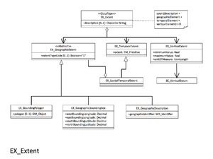
| 1 | description | 0..1 | Mandatory when geographicElement, temporalElement and verticalElement are not present. When there are multiple extents, this field is useful for identifying each extent. |
extent:  (EX_Extent)
 geographicElement:  (EX_GeographicBoundingBox)
   westBoundLongitude:  -171.76409
   eastBoundLongitude:  -157.86768
   southBoundLatitude:  -14.42443
   northBoundLatitude:  21.31573
 temporalElement:  (EX_TemporalExtent)
  extent:
   TimePeriod:
    beginPosition:  2010-05-17
    endPosition:  2010-06-16
extent:  (EX_Extent)
 description:  KingmanPalmyra_line_100
 geographicElement:  (EX_GeographicBoundingBox)
   westBoundLongitude:  -162.14217
   eastBoundLongitude:  -161.55155
   southBoundLatitude:  4.94414
   northBoundLatitude:  5.28984
 temporalElement:  (EX_TemporalExtent)
  extent:
   TimePeriod:
    beginPosition:  2010-06-05T12:00:17
    endPosition:  2010-06-05T15:15:37
|
| 2 |
geographicElement (choose one) |
0..* | Geographic extent of the resource. At a minimum, provide the GeographicBoundingBox, because most discovery systems rely on this section for spatial searches. Not required when resource is non-geospatial and the scopeCode = 'nonGeographicDataset'. | |
| 3 |
temporalElement (choose one) |
0..* | Temporal extent of the resource. Describe the time period covered by the content of the resource or the date and time range when the data was collected. The use of multiple temporal extents should be explained in the attribute description of the extent. If the resource has a status of 'ongoing' then use the indeterminatePosition attribute without an end date value. Example: <gml:endPosition indeterminatePosition="now"/> | |
| 4 | verticalElement | 0..* | Minimum and maximum vertical extent of the resource. | |


