ESIP
<Back to Data Summit Workspace <All Data Systems
Edit with Form or Submit Word Doc
General
Contact
Data System Name: ESIP
Data System URL: http://wiki.esipfed.org/index.php/Air Quality Cluster
Contact Person: Air Quality Cluster
Contact e-mail: esip-aqcluster@rtpnet.org
Background
About the Data System (Purposes, Audience)
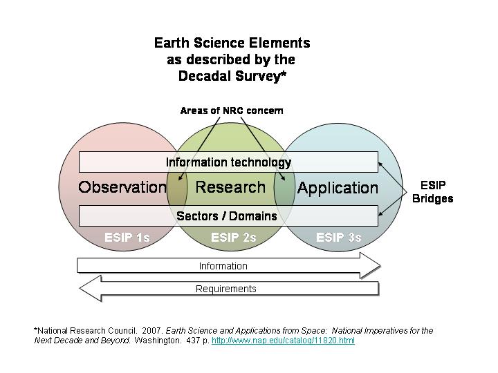
[[About::The Federation of Earth Science Information Partners (ESIP) is a consortium of over 100 organizations in government academia, and industry that collect, disseminate, interpret and apply Earth observation information. ESIP serves as a forum for fostering and sustaining collaborations and interoperability that aim to improve processes for the use of earth observation information in research, education, management and policy.
ESIP "clusters" are domain-specific focus groups that are intended to promote informal, easy exchange of information among organizations. The ESIP Air Quality Cluster aims to connect air quality data consumers and providers by:
- bringing people and ideas together on how to deliver ES data to AQ researchers, managers and other users/consumers
- facilitate and demonstrate the information flow of from data providers to air quality consumer
Presentation
http://wiki.esipfed.org/images/9/92/ESIP Overview2.ppt
History
- 1998 - ESIP Formed by NASA in Response to a NRC Recommendation for "Community Involvement" in EOSDIS.
- 2003 – Evolved Plan to Become a Broad-Based Inter-Disciplinary Collaborative Forum (Cyberinfrastructure) for the Earth Science Information Community.
- 2004 - NOAA/NESDIS Becomes Second Strategic Partner.
- 2005 - Air Quality Cluster formed
- 2007 – EPA/ORD becomes Third Strategic Partner
- 2003-2007 – Membership Grows from 27 to 106 Entities.
Agencies
NASA, NOAA, EPA are strategic partners
List of Publications, Papers, Presentations
See activity pages, presentations and concept papers at http://wiki.esipfed.org/index.php/Air_Quality_Cluster
Data System Scope
Data Content
Datasets Served
[[DataSystemDataSets::ESIP is not a data system in the sense of producing or directly serving data. However, many of its members are data producers. ESIP serves as broker for earth science data ranging from satellite imagery to surface observations and models. ESIP provides a forum to aggregate and synthesize metadata for dataset descriptions, discussions about dataset applications and tools for analyzing and visualizing data. See DataSpaces]]
Parameters
Broad range
Spatial - Temporal Coverage
Depends on data source (global to regional and historical to nea real time).
Applications/Potential
Health
[[DataSystemAppHealth::The Public Health Applications in Remote Sensing (PHAiRS) project is an active ESIP participant and its connection to DataFed for access to air quality data was facilitated by ESIP: PHAiRS_-_DataFed_Interaction.]]
Forecasting and Reanalysis
Not Given
Model/Emissions Evaluation
Not Given
Characterization, Trends, Accountability
Not Given
Other
ESIP does not focus on a particular application area but its organizational framework, diverse participation, and information science and technology expertise form an environment to support air quality applications.
Data System IT
Primary/Official Store for Some data
No. Although many of its members provide that service.
Data Consolidation/integration
Metadata aggregator. Provide domain-specific context for data where metadata and other contextual information about earth science data is available to help understand how data are created and used.
Providing Data Access to users/externals
Promote the integration and flow of Earth science data from collection and analysis to end-use.
Data Processing
Not Given
Visualization/Analysis
Not Given
Decision Support (e.g. some integration into user business process)
Not Given
End-to-End Integration
Promote the integration and flow of Earth science data from collection and analysis to end-use.
Other DS Values
Not Given
Data Access and/or Output Interoperability
ESIP promotes the use of standards for data interoperability. The ESIP semantic web cluster is exploring new technologies for enhancing data access and interoperability.
Reusable Tools and Methods
Use of wiki, portals, catalogs. Guidance on best practices. Promotes web services and service oriented architecture approaches to reuse.
Security Barriers and Solutions
Not Given
User Feedback Approach
Wikis. Metadata. Semantic web (ontologies).
Other Architecture
Not Given
User Provided Content
ESIP
Goals
- Serve as facilitator and advisor for the Earth science information community.
- Promote efficient flow of Earth science data from collection to end-use.
- Improve quality and usability of Earth science data and information systems.
- Expand the use of Earth science information – get it to the decision-makers.
- Educate the public about Earth science and science information systems.
Activities
- Provides Neutral Turf where Major Earth Observing Agencies Can Work Together with Other Community Interests to Advance Key National Objectives
- Provide a Broad-Based Community-of-Practice where Strategic Partners can Seek Advice, Generate New Collaborations and Cultivate New End-Users.
- Provide a Forum in which Inter-Agency, Inter-Disciplinary, Interoperability Problems can be Addressed and Resolved.
- Provide an Earth Information Exchange where the Products and Services of all ESIP Members can be Easily Found and Acquired.
- Provide domain-specific context for data where metadata and other contextual information about earth science data is available to help understand how data are creating and used
