< Back to DataSpaces
AVHRR - AVHRR
Viewers:  | | 
|
Description: Dataset Description Parameters: No Parameters Given
Domain: Aerosol |
Platform: Satellite | Instrument: No Instrument |
Method: RemoteSens |
Type: No DataType | Periodicity: No Periodicity"No Periodicity" is not in the list (HOUR, HALF_HOUR, SIX_HOURS, DAY, WEEK, MONTH, YEAR, FIVE_YEARS, NONE) of allowed values for the "Periodicity" property. | GeoRange: No GeoRange"No GeoRange" is not in the list (NAM, US, EUR, GLOB, SEASIA, SAM, SWASIA, AFRICA) of allowed values for the "GeoRange" property. | Time Period: No TimePeriod"No TimePeriod" is not in the list (REALTIME, HIST, FORECAST) of allowed values for the "TimePeriod" property.
Key Use: No Key Uses
Data Access Services: WMS | WCS
|
|
NOAA

Provider
No Distributor
Source
Citation
Lineage
|
User-Contributioned Resources. See also discussion page. Help on Edit.
Dataset Description
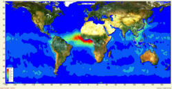
AVHRR is a four-image dataset representing the global oceanic aerosol optical depth derived from the AVHRR sensor 1989-1991 (Husar et al., 1997).
http://webapps.datafed.net/datafed.aspx?dataset_abbr=AVHRR
Related Links
Additional Information
Edit AVHRR-RDF | View AVHRR-RDF

