Difference between revisions of "ASOS STI"
(New page: {{Dataset |DatasetTitle=ASOS Surface Extinction Coefficient by STI |DatasetDesc=ASOS_STI represents a 250-station subset of the national ASOS SURF_MET dataset. The unique feature of this d...) |
|||
| (3 intermediate revisions by 2 users not shown) | |||
| Line 1: | Line 1: | ||
{{Dataset | {{Dataset | ||
|DatasetTitle=ASOS Surface Extinction Coefficient by STI | |DatasetTitle=ASOS Surface Extinction Coefficient by STI | ||
| − | |DatasetDesc=ASOS_STI represents a 250-station subset of the national ASOS SURF_MET dataset. The unique feature of this data is that the visibility sensor values are available in an un-truncated, high resolution form | + | |DatasetDesc=ASOS_STI represents a 250-station subset of the national ASOS SURF_MET dataset. The unique feature of this data is that the visibility sensor values are available in an un-truncated, high resolution form. |
|Domain=Aerosol | |Domain=Aerosol | ||
|SamplePlatform=Network | |SamplePlatform=Network | ||
|SampleMethod=Point | |SampleMethod=Point | ||
|DataType=POINT | |DataType=POINT | ||
| − | |Parameters= | + | |GeoRange=US |
| + | |TimePeriod=HIST | ||
| + | |Periodicity=HOUR | ||
| + | |Parameters=Wind, Temp, Visibility | ||
|ProviderAbbr=STI | |ProviderAbbr=STI | ||
|ProviderURL=http://www.sonomatech.com/ | |ProviderURL=http://www.sonomatech.com/ | ||
|DataAccessURL=http://www.sonomatech.com/ | |DataAccessURL=http://www.sonomatech.com/ | ||
|CitationURL=http://www.sonomatech.com/ | |CitationURL=http://www.sonomatech.com/ | ||
| − | |||
| − | |||
| − | |||
| − | |||
| − | |||
| − | |||
| − | |||
| − | |||
| − | |||
| − | |||
| − | |||
| − | |||
| − | |||
| − | |||
| − | |||
}} | }} | ||
| + | ===Description continued=== | ||
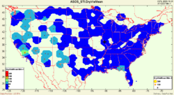
| + | This dataset indicates that the sensitivity of the ASOS sensor is about 25 miles, which allows spatial-temporal analysis of haze events using the in situ ASOS sensors. The ASOS_STI dataset is provided to the FASTNET project by Sonoma Technology Inc. using a web-based interface. | ||
| + | |||
{{Addition Dataset Information}} | {{Addition Dataset Information}} | ||
Latest revision as of 13:55, January 24, 2008
ASOS_STI - ASOS Surface Extinction Coefficient by STI
 |
Description: ASOS_STI represents a 250-station subset of the national ASOS SURF_MET dataset. The unique feature of this data is that the visibility sensor values are available in an un-truncated, high resolution form. Parameters: Wind, Temp, Visibility |
- Browse Fields
- RDF for ASOS_STI <- Should be a property
- What Links here on ESIP wiki
- 400px
Description continued
This dataset indicates that the sensitivity of the ASOS sensor is about 25 miles, which allows spatial-temporal analysis of haze events using the in situ ASOS sensors. The ASOS_STI dataset is provided to the FASTNET project by Sonoma Technology Inc. using a web-based interface.
