< Back to DataSpaces
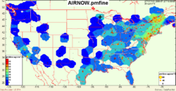
AIRNOW - Surface Monitoring Data for PM2.5 and Ozone
Viewers:  | | 
|
Description: AIRNOW is a cooperative State-EPA program to gather and distribute near-realtime PM2.5 and ozone data over the US data from several hundred sites located mostly in urban areas. Parameters: PM2.5, PM10, Ozone
Domain: Aerosol |
Platform: Network | Instrument: No Instrument |
Method: Point |
Type: POINT | Periodicity: No Periodicity"No Periodicity" is not in the list (HOUR, HALF_HOUR, SIX_HOURS, DAY, WEEK, MONTH, YEAR, FIVE_YEARS, NONE) of allowed values for the "Periodicity" property. | GeoRange: No GeoRange"No GeoRange" is not in the list (NAM, US, EUR, GLOB, SEASIA, SAM, SWASIA, AFRICA) of allowed values for the "GeoRange" property. | Time Period: No TimePeriod"No TimePeriod" is not in the list (REALTIME, HIST, FORECAST) of allowed values for the "TimePeriod" property.
Key Use: No Key Uses
Data Access Services: WMS | WCS
|
|
EPA

Provider
No Distributor
Source
Citation
Lineage
|