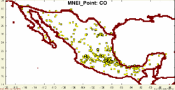
MNEI Point
From Earth Science Information Partners (ESIP)
MNEI_Point - Mexican National Emissions Inventory
 |
Description: Mexican National Emissions Inventory for Point Sources 1999 Parameters: CO, NOx, PM10, PM25, SO2, VOC |
SEMARNAT_INE |
- Browse Fields
- RDF for MNEI_Point <- Should be a property
- What Links here on ESIP wiki
- 400px
User-provided Metadata
MNEI_Point FAQ's
Lineage
Websites
Websites tagged in Point+Link Del.icio.us with: MNEI Point Link
Papers
Papers tagged in Point+Paper Del.icio.us with: dataset MNEI Point Paper
Automatic Searches
- Google Search | Blogs | Scholar | Images | News | Video - AirNOW + EPA
- Technorati Blogs - AirNOW + EPA
- Del.icio.us - AIRNOW
