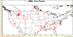
HMS Fire
HMS_Fire - Dataset Title
 |
Description: HMS_Fire and MODIS_Fire location maps are provided by NOAA's Satellite Services Division (http://gp16.wwb.noaa.gov/FIRE/fire.html). Both the MODIS and HMS fire location data are available for freely open ftp download from ftp://gp16.wwb.noaa.gov/pub/FIRE/ Parameters: No Parameters Given |
- Browse Fields
- RDF for HMS_Fire <- Should be a property
- What Links here on ESIP wiki
- 400px
User-Contributioned Resources. See also discussion page. Help on Edit.
Dataset Description
HMS_Fire location maps are provided by NOAA's Satellite Services Division (http://gp16. wwb.noaa.gov/FIRE/fire.html). Both the MODIS and HMS fire location data are available for ftp download from ftp://gp16.wwb.noaa.gov/pub/FIRE/. Only the most recent dayss are archived. CAPITA has written and maintains a SQL Server Data Transformation Service for dailyaccess and storage of the ftp accessible ASCII data files. The fire location data are useful for analyzing the spatial and temporal distribution of detected fires and in identifying source locations for smoke plumes.
