GEOSS User Requirements Registry
Introduction
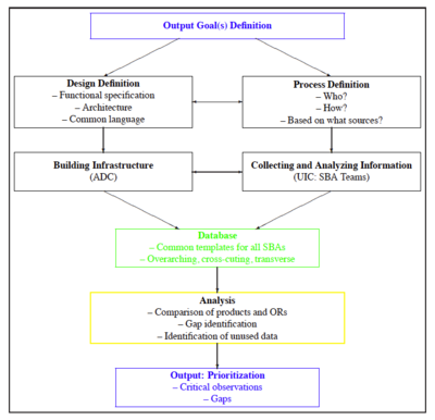
For the planning, implementation, and future development of GEOSS as a system (of systems) that is driven by and responding to well-defined user needs, a utility that allows the comparison of the products provided by GEOSS to the requirements in terms of Earth observations and higher level information of applications supported by GEOSS is a powerful if not mandatory tool to identify gaps in the observation system and to define priorities for the development of GEOSS.
A necessary basis for this UNSPU is a comprehensive database describing the user types in the nine Societal Benefit Areas (SBAs), their needs and applications, the qualitative and quantitative requirements in terms of Earth observations and derived information, and the services and products provide by GEOSS. Utilizing this database, algorithms for system performance assessment and gap analysis can be developed. The output of these algorithms provides a basis for informed decisions on priorities for the system development.
The functional specifications for the UNSPU address the publishing, editing, search and analysis functions to be supported by the UNSPU. They define the contents of the database as well as the output that the utility will be able to provide
Functional Specification of UNSPU
URR Components:
- Applications: registry of applications using GEOSS observations and/or products and/or producing products for other applications;
- User Types: registry of GEOSS user types, groups and classes;
- Requirements: list of quantitative requirements for GEOSS observations and products;
- Properties: registry of properties, that is, variables and products that are related to the Earth system’s state and trends;
- Specifications: Agreed upon specifications of system performance in terms of products and their characteristics;
- Techniques: registry of observation techniques..observed variables, accuracy, resolution, latency, reliability, availability, status;
- Observations: registry of observations available to GEOSS;
- Products: list of products (may include observations) made available through GEOSS services, including a quantitative characterization.
Link Functions:
- the linkage of applications to applications;
- the linkage of user types to applications and applications to user types;
- the linkage of applications to requirements and requirements to applications;
- the linkage of observations to products and products to observations.
Edit functions for GEO members:
- registration of user types;
- registration of applications.
Administrative Editing:
- Properties;
- Techniques;
- Requirements;
- Specifications;
- Observations;
- Products;
- All links.
Analysis functions:
- identification of deviations of system performance from specifications;
- identification of requirements not met by products and applications not receiving the required products (gaps analysis);
- identification of user types not able to utilize the full benefit of Earth observations.
