Difference between revisions of "EX VerticalExtent"
From Earth Science Information Partners (ESIP)
m |
|||
| (2 intermediate revisions by 2 users not shown) | |||
| Line 1: | Line 1: | ||
| + | == gex:EX_VerticalExtent == | ||
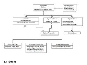
| + | [[File:EX_Extent.png|thumb|right|EX_Extent]] | ||
Minimum and maximum vertical extent of the resource. Recommended if your resource has vertical coverage. | Minimum and maximum vertical extent of the resource. Recommended if your resource has vertical coverage. | ||
| − | <table cellpadding="3"> | + | <table cellpadding="3" width="100%"> |
<tr> | <tr> | ||
<th colspan="3">Elements</th> | <th colspan="3">Elements</th> | ||
| − | <th>< | + | <th colspan="1">Domain</th> |
| − | <th>< | + | <th width="50%">Definition and Recommended Practice</th> |
| + | <th width="30%"><i>Examples</i></th> | ||
</tr> | </tr> | ||
<tr> | <tr> | ||
<td bgcolor="FFFF99">1</td> | <td bgcolor="FFFF99">1</td> | ||
| − | <td bgcolor="FFFF99">[[Real|minimumValue]]</td> | + | <td bgcolor="FFFF99">[[Real|gex:minimumValue]]</td> |
<td bgcolor="FFFF99">1</td> | <td bgcolor="FFFF99">1</td> | ||
| − | <td>< | + | <td bgcolor="FFFF99">[[Real|gco:Real]]</td> |
| − | <td>< | + | <td>Lowest vertical extent contained in the dataset.</td> |
| + | <td><i>minimumValue: 3600</i></td> | ||
</tr> | </tr> | ||
<tr> | <tr> | ||
<td bgcolor="FFFF99">2</td> | <td bgcolor="FFFF99">2</td> | ||
| − | <td bgcolor="FFFF99">[[Real|maximumValue]]</td> | + | <td bgcolor="FFFF99">[[Real|gex:maximumValue]]</td> |
<td bgcolor="FFFF99">1</td> | <td bgcolor="FFFF99">1</td> | ||
| − | <td>< | + | <td bgcolor="FFFF99">[[Real|gco:Real]]</td> |
| − | <td>< | + | <td>Highest vertical extent contained in the dataset.</td> |
| + | <td><i>maximumValue: 3100</i></td> | ||
</tr> | </tr> | ||
<tr> | <tr> | ||
| − | <td bgcolor=" | + | <td bgcolor="CCFF99">3</td> |
| − | <td bgcolor=" | + | <td bgcolor="CCFF99">[[MD_ReferenceSystem|gex:verticalCRSId]]</td> |
| − | <td bgcolor=" | + | <td bgcolor="CCFF99">0..1</td> |
| − | <td><i>Vertical coordinate reference system. Recommend referencing EPSG codes with an XLink instead of populating this section. | + | <td bgcolor="CCFF99">[[MD_ReferenceSystem|mrs:MD_ReferenceSystem]]</td> |
| − | <td> | + | <td>Mandatory if gex:verticalCRS is not present</td> |
| − | < | + | <td><i></i></td> |
| − | xlink:href="http://www.epsg-registry.org/export.htm?gml=urn:ogc:def:crs:EPSG::5715" | + | </tr> |
| − | xlink:title="msl depth in meters" xlink:actuate="onRequest" | + | <tr> |
| − | </td> | + | <td bgcolor="CCFF99">4</td> |
| + | <td bgcolor="CCFF99">[[VerticalCRS|gex:verticalCRS]]</td> | ||
| + | <td bgcolor="CCFF99">0..1</td> | ||
| + | <td bgcolor="CCFF99">[[VerticalCRS|CRS]] <i>(need more info)</i></td> | ||
| + | <td><i>Mandatory if gex:verticalCRSId is not present</i><br>Vertical coordinate reference system. Recommend referencing EPSG codes with an XLink instead of populating this section.</td> | ||
| + | <td><i>verticalCRS: | ||
| + | :xlink:href="http://www.epsg-registry.org/export.htm?gml=urn:ogc:def:crs:EPSG::5715" | ||
| + | :xlink:title="msl depth in meters" xlink:actuate="onRequest"</i></td> | ||
</tr> | </tr> | ||
</table> | </table> | ||
| − | + | <br> | |
| − | |||
{{template:isoOrderingFooter}} | {{template:isoOrderingFooter}} | ||
* [[ISO_Extents]] | * [[ISO_Extents]] | ||
* [[Documentation_Spirals#Extent]] | * [[Documentation_Spirals#Extent]] | ||
Latest revision as of 09:13, August 15, 2017
gex:EX_VerticalExtent
Minimum and maximum vertical extent of the resource. Recommended if your resource has vertical coverage.
| Elements | Domain | Definition and Recommended Practice | Examples | ||
|---|---|---|---|---|---|
| 1 | gex:minimumValue | 1 | gco:Real | Lowest vertical extent contained in the dataset. | minimumValue: 3600 |
| 2 | gex:maximumValue | 1 | gco:Real | Highest vertical extent contained in the dataset. | maximumValue: 3100 |
| 3 | gex:verticalCRSId | 0..1 | mrs:MD_ReferenceSystem | Mandatory if gex:verticalCRS is not present | |
| 4 | gex:verticalCRS | 0..1 | CRS (need more info) | Mandatory if gex:verticalCRSId is not present Vertical coordinate reference system. Recommend referencing EPSG codes with an XLink instead of populating this section. |
verticalCRS:
|


