ISRSE Demonstration - Stresa, Italy. May 2009
Highlighted ESIP Federation Partners
The demonstration in Stresa highlights the products and services of several ESIP Federation members.
Global Change Master Directory (GCMD)
The GCMD database holds more than 25,000 descriptions of Earth science data sets and services covering all aspects of Earth and environmental sciences. One can use the search box or select from the available keywords to search for data and services. We encourage your participation in writing and maintaining the information in our databases. You will find authoring tools to assist you. In addition, Subscription services are available to notify you of new entries. The Committee on Earth Observation Satellites (CEOS) International Directory Network (IDN) Interoperability Forum is available to discuss content and database issues.
Included in the holdings of GCMD is a specialized portal for discovering ESIP Federation Products and Services.
Oak Ridge National Laboratory Distributed Active Archive (ORNL DAAC)
Earth Data Analysis Center (EDAC)
Since 1964, the Earth Data Analysis Center has focused on the transfer of science products to end-users in a wide variety of research and application domains including public health, transportation, natural resources management, and international remote sensing applications. Common to these application areas are the application of state-of-the-art geospatial technologies to the problems at hand.
One recent NASA funded project is the Public Health in Remote Sensing Project (PHAiRS) in which, in collaboration with researchers at the University of Arizona and George Mason University, a services oriented architecture for the delivery of near-real-time dust forecast data to public health decision makers.
University of Wisconsin Space Science and Engineering Center (SSEC)
Satellite Observations in Science Education SOSE
The purpose of this site is to improve the teaching and learning of the Earth system through quality educational resources that make use of satellite observations. Recognizing the increasing importance of online learning techniques, this site makes freely available a library of Reusable Content Objects (RCOs) - a toolkit adaptable to a wide variety of applications. Using this toolkit, an educator can quickly assemble highly interactive web-based activities.
The site also provides access to real-time satellite data via a very simple (one click) interface.
Sponsored by NASA, developed and hosted by the University of Wisconsin Space Science and Engineering Center, SSEC Contact information available on the site.
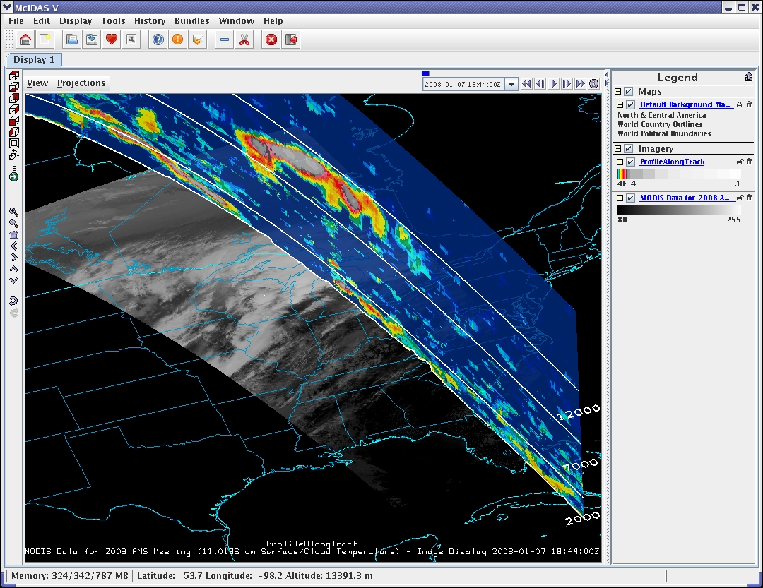
McIDAS-V McIDAS-V
McIDAS-V is a free, open source, visualization and data analysis software package that is the next generation in SSEC's 35-year history of sophisticated McIDAS software packages. McIDAS-V displays weather satellite (including hyperspectral) and other geophysical data in 2- and 3-dimensions. McIDAS-V can also analyze and manipulate the data with its powerful mathematical functions.
Developed by the University of Wisconsin Space Science and Engineering Center, SSEC
Screenshot follows:
Open Geospatial Consortium Web Map Services (WMS) Demonstration
A large number of ESIP Federation members host WMS services for their data products. Several of these services have been integrated into a demonstration client hosted by the Earth Data Analysis Center, at the University of New Mexico.
