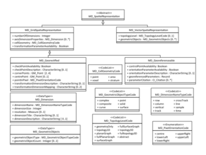
MD GridSpatialRepresentation
From Earth Science Information Partners (ESIP)
| Elements | Definition and Recommended Practice | Examples |
||
|---|---|---|---|---|
| 1 | numberOfDimensions | 1 | number of independent spatial-temporal axes | Example is needed |
| 2 | axisDimensionProperties | 0..* | information about spatial-temporal axis properties | Example is needed |
| 3 | cellGeometry | 1 | identification of grid data as point or cell | Example is needed |
| 4 | transformationParameterAvailability | 1 | indication of whether or not parameters for transformation between image coordinates and geographic or map coordinates exist (are available) | Example is needed |
OR
| MD_Georeferenceable / MI_Georeferenceable |
|---|
OR
| MD_Georectified / MI_Georectified |
|---|
Please contribute!
- transformationParameterAvailability
- indication of whether or not parameters for transformation between image coordinates and geographic or map coordinates exist (are available).
- Plain English
- Select yes, if the map coordinates are available in the file headers or related dataset documentation have enough information to re-project the data.


