Difference between revisions of "EX GeographicBoundingBox"
From Earth Science Information Partners (ESIP)
m (1 revision: Importing the ISO Explorer Category from GEO-IDE Wiki (Ted Habermann)) |
|||
| Line 1: | Line 1: | ||
| + | == gex:EX_GeographicBoundingBox == | ||
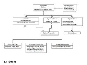
| + | [[Image:EX Extent.png|thumb|right|EX Extent.png]] | ||
Bounding coordinates of the maximum geospatial extent in decimal degrees. Not required resource is non-geospatial and the resource scopeCode = 'nonGeographicDataset'. When there are multiple extents, provide the bounding coordinates at the top with the id attribute of 'boundingGeographicBoundingBox'. | Bounding coordinates of the maximum geospatial extent in decimal degrees. Not required resource is non-geospatial and the resource scopeCode = 'nonGeographicDataset'. When there are multiple extents, provide the bounding coordinates at the top with the id attribute of 'boundingGeographicBoundingBox'. | ||
| − | <table cellpadding="3"> | + | <table cellpadding="3" width="100%"> |
<tr> | <tr> | ||
<th colspan="3">Elements</th> | <th colspan="3">Elements</th> | ||
| − | <th>< | + | <th colspan="1">Domain</th> |
| − | <th>< | + | <th width="60%">Definition and Recommended Practice</th> |
| + | <th width="20%"><i>Examples</i></th> | ||
</tr> | </tr> | ||
<tr> | <tr> | ||
<td bgcolor="CCFFFF">1</td> | <td bgcolor="CCFFFF">1</td> | ||
| − | <td bgcolor="CCFFFF">[[Boolean|extentTypeCode]] </td> | + | <td bgcolor="CCFFFF">[[Boolean|gex:extentTypeCode]]</td> |
<td bgcolor="CCFFFF">0..1</td> | <td bgcolor="CCFFFF">0..1</td> | ||
| − | <td>< | + | <td bgcolor="CCFFFF">[[Boolean|gco:Boolean]]</td> |
| − | < | + | <td>Indication of whether the bounding polygon encompasses an area covered by the data or an area where data is not present. Default assumption is that the bounding area is where the data is present.</td> |
| + | <td rowspan="5"><i>EX_GeographicBoundingBox | ||
| + | :westBoundLongitude: -179.716 | ||
| + | :eastBoundLongitude: 179.883 | ||
| + | :southBoundLatitude: -65.616 | ||
| + | :northBoundLatitude: 56.166</i></td> | ||
</tr> | </tr> | ||
<tr> | <tr> | ||
| − | <td bgcolor="FFFF99"> 2 </td> | + | <td bgcolor="FFFF99">2</td> |
| − | <td bgcolor="FFFF99">[[Decimal|westBoundLongitude]]</td> | + | <td bgcolor="FFFF99">[[Decimal|gex:westBoundLongitude]]</td> |
| − | <td bgcolor="FFFF99"> 1 </td> | + | <td bgcolor="FFFF99">1</td> |
| − | <td>< | + | <td bgcolor="FFFF99">[[Decimal|gco:Decimal]]</td> |
| − | + | <td>Westernmost coordinate of the limit of the dataset extent, expressed in longitude in decimal degrees.</td> | |
| − | |||
| − | |||
| − | |||
| − | |||
| − | |||
| − | |||
| − | |||
| − | |||
| − | |||
| − | |||
| − | |||
| − | |||
| − | |||
| − | |||
| − | |||
| − | </td> | ||
</tr> | </tr> | ||
<tr> | <tr> | ||
| − | <td bgcolor="FFFF99"> 3</td> | + | <td bgcolor="FFFF99">3</td> |
| − | <td bgcolor="FFFF99">[[Decimal|eastBoundLongitude]]</td> | + | <td bgcolor="FFFF99">[[Decimal|gex:eastBoundLongitude]]</td> |
<td bgcolor="FFFF99">1</td> | <td bgcolor="FFFF99">1</td> | ||
| − | <td>< | + | <td bgcolor="FFFF99">[[Decimal|gco:Decimal]]</td> |
| + | <td>Easternmost coordinate of the limit of the dataset extent, expressed in longitude in decimal degrees.</td> | ||
</tr> | </tr> | ||
<tr> | <tr> | ||
| − | <td bgcolor="FFFF99"> 4</td> | + | <td bgcolor="FFFF99">4</td> |
| − | <td bgcolor="FFFF99">[[Decimal|southBoundLatitude]] </td> | + | <td bgcolor="FFFF99">[[Decimal|gex:southBoundLatitude]] </td> |
<td bgcolor="FFFF99">1</td> | <td bgcolor="FFFF99">1</td> | ||
| − | <td>< | + | <td bgcolor="FFFF99">[[Decimal|gco:Decimal]]</td> |
| + | <td>Southernmost coordinate of the limit of the dataset extent, expressed in latitude in decimal degrees.</td> | ||
</tr> | </tr> | ||
<tr> | <tr> | ||
| − | <td bgcolor="FFFF99"> 5</td> | + | <td bgcolor="FFFF99">5</td> |
| − | <td bgcolor="FFFF99">[[Decimal|northBoundLatitude]] </td> | + | <td bgcolor="FFFF99">[[Decimal|gex:northBoundLatitude]] </td> |
<td bgcolor="FFFF99">1</td> | <td bgcolor="FFFF99">1</td> | ||
| − | <td>< | + | <td bgcolor="FFFF99">[[Decimal|gco:Decimal]]</td> |
| + | <td>Northernmost coordinate of the limit of the dataset extent, expressed in latitude in decimal degrees.</td> | ||
</tr> | </tr> | ||
</table> | </table> | ||
| − | + | <br> | |
| − | |||
{{template:isoOrderingFooter}} | {{template:isoOrderingFooter}} | ||
Latest revision as of 06:17, August 15, 2017
gex:EX_GeographicBoundingBox
Bounding coordinates of the maximum geospatial extent in decimal degrees. Not required resource is non-geospatial and the resource scopeCode = 'nonGeographicDataset'. When there are multiple extents, provide the bounding coordinates at the top with the id attribute of 'boundingGeographicBoundingBox'.
| Elements | Domain | Definition and Recommended Practice | Examples | ||
|---|---|---|---|---|---|
| 1 | gex:extentTypeCode | 0..1 | gco:Boolean | Indication of whether the bounding polygon encompasses an area covered by the data or an area where data is not present. Default assumption is that the bounding area is where the data is present. | EX_GeographicBoundingBox
|
| 2 | gex:westBoundLongitude | 1 | gco:Decimal | Westernmost coordinate of the limit of the dataset extent, expressed in longitude in decimal degrees. | |
| 3 | gex:eastBoundLongitude | 1 | gco:Decimal | Easternmost coordinate of the limit of the dataset extent, expressed in longitude in decimal degrees. | |
| 4 | gex:southBoundLatitude | 1 | gco:Decimal | Southernmost coordinate of the limit of the dataset extent, expressed in latitude in decimal degrees. | |
| 5 | gex:northBoundLatitude | 1 | gco:Decimal | Northernmost coordinate of the limit of the dataset extent, expressed in latitude in decimal degrees. | |
Please contribute!
The EX_GeographicBoundingBox is intended to represent the geographic area of the entire dataset referenced to WGS 84


