Networking of Air Quality Data
What links here: Networking of Air Quality Data > GEO_GEOSS
Back to <Data Summit Workspace
Back to <Community Air Quality Data System Workspace
GEO: Home | About | Chairs Letter | Meetings | Brochure | Documents
GEOSS: Architecture and Data | Science and Technology | User Interface | Capacity Building | GEOSS AIP AQ Scenario | Core AI Report | Other Resources
Background
The mission of the Environmental Protection Agency is to protect human health and the environment. Air quality management involves many activities including setting and maintaing air quality standards, monitoring trends, informing the public, etc. Each of these activities have different information needs. In the past both the monitoring and assessment of air quality has been performed in specific programs each directed and somewhat confined to the specific applications that they served.
Recently, the Agency developed and now is in the process of implementing a new National Air Monitoring Strategy(NAMS). NAMS was designed to produce more reusable datasets for multiple programs/applications in EPA. Implicit in the new strategy is that there is a corresponding new Information System strategy that facilitates the access, processing/analysis/integration of broad range of data applicable to multiple uses.
GEOSS and Air Quality Data Systems
At the international level, the 70-nation Group on Earth Observations (or GEO) is coordinating international efforts to build a Global Earth Observation System of Systems (GEOSS). This emerging public infrastructure (system of systems) is interconnecting a diverse and growing array of instruments and systems for monitoring and forecasting changes in the global environment.
The common characteristics of both the planned EPA and GEOSS information systems are:
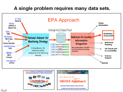
- A single problem requires many data sets.
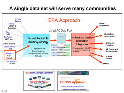
- A single data set will serve many communities
The above two characteristics of the information system puts high demand on the architecture of the information system that facilitates the flow of the data resources from the providers to the users via a suitable data processing chain. An ingeneous solution to the many-to-many connections is illustrated schematically in the above "bow-tie" or fan in-fan out representation. The left hand side, fan in section, represents the collection of the distributed data resources into a common data access system, represented by the barrel. The potential users of the data, shown on the right hand side, satisfy their data by selecting from the common data pool. The fan out represents the fact that each user may need different combination of data and processing services.
It is recognized that creating a common database that collects all the relavent data and metadata into a single physical database is not practical. An alternative is the network approach where data and information services represent nodes in a network that can be dynamically connected to form user-driven data flow systems.
GEOSS, like the Internet, connects data/information providers and users; to deliver reliable, up-to-date and user friendly information – vital for the work of decision makers, planners and emergency managers. The GEOSS Approach is to build on existing systems, register and catalog reusable components provided voluntarily by the member organizations and to facilitate integration of these components through international standard interfaces.
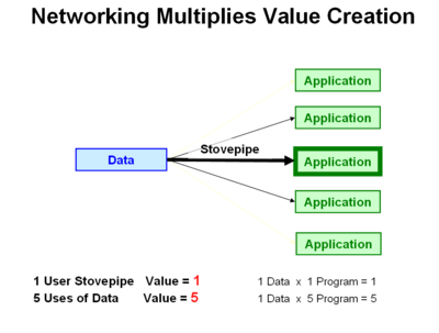
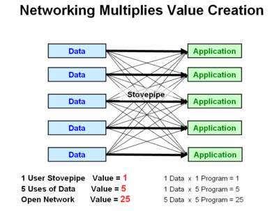
Networking through the dynamic creation of loosely connected components has the potential to produce the well-known "Network Effect", where the value of the network increases in proportion to the number of network nodes squared. This non-linear behavior of producing overall value to the community is illustrated schematically below.
Preface
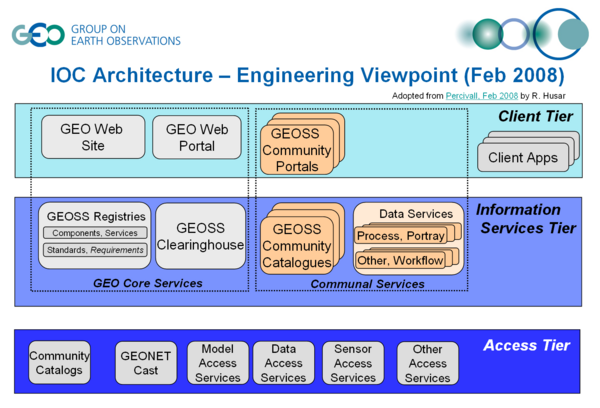
The GEOSS Core Architecture for exchange and dissemination of observations consists of the GEO Web Portal, Clearinghouse, and Registry components along with a process to register, discover and use services accessible using GEOSS Interoperability Arrangements. During 2007, the GEO Architecture Data Committee (ADC), through its core tasks, has guided development of an Initial Operating Capability (IOC) of the GEOSS Core Architecture. Results of the development were demonstrated to multiple GEO members in September 2007, including use of the services for several Societal Benefit Areas. This report provides an evaluation of the IOC with a particular focus on pilot-level versions of several GEO Web Portals, Clearinghouses and Registries. It is anticipated that this report will be used for future phases of GEOSS development. This report captures a work in progress. The report provides descriptions of the implementations that have been achieved to date as well providing recommendations on how the implementations should continue.
[ Current Architecture] has several shortcomings that need to be addressed in future stages of development.
- Metadata for Datasets. The current architecture is geared toward standardized approach to data: access, processing, portayal, delivery. There is no explicit provision for the accompanying metadata. There is no standard approach for encoding, gathering, and delivery of metadata. This means that the user has little information about the data sensors and platforms, lineage, quality, processing, past applications, etc.
- Metadata for Services. Services operating on data may be well-defined in terms of the syntax for the interface. In case of SOAP-WSDL protocol, the interface syntax is encoded in the WSDL XML document. This allows automatic type-checking of service components to be connected. However, neither the semantic meaning of the interface parameters, nor the functionality of individual services is definable in the current systems. An exception is a set of OGC web services which specifies both the interaction protocol and the semantics of the interfaces.
- Missing the Service Chaining.
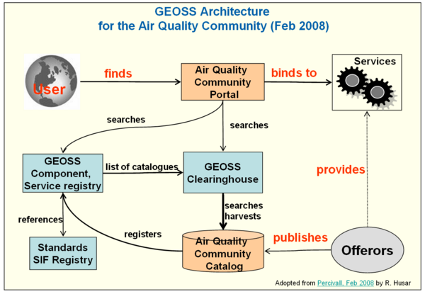
2008-02-25: GEOSS Architecture Schematics, rbh
7.2 GEO Web Portal Definition
A Web portal is a single point of access to information, which is linked from various logically related Internet based applications and is of interest to various types of users. The GEOSS architecture (Section 5.3) defines two types of portals: a GEO Web Portal and GEOSS Community Portals. Portals present information from diverse sources in a unified way; they provide a consistent look and feel with access control and procedures for multiple applications, which otherwise would have been different entities altogether. Since all the applications share information through portals, there is better communication between various types of users. Another advantage of portals is that they can make event-driven campaigns. Generally, a portal provides:
- Intelligent integration and access to enterprise content, applications and processes
- Improved communication and collaboration among customers, partners, and employees
- Unified, real-time access to information held in disparate systems
- Personalized user interactions
- Rapid, easy modification and maintenance of the website presentation
The following are the properties of portals:
- Look and feel
- Consistent headers and footers, color schemes, icons and logos which gives the user a feel and sense of consistency, uniformity, and ease of navigation
Related topics:
- AirNOW Data System Design Topics
- DSS Architectures
- Applications of AirNOW Data
- GEOSS and the AirNOW Data System
- EPA Air Quality Data Systems and GEOSS Architecture
Community Air Quality Data System WorkspaceNetworking of Air Quality Data Data Summit Workspace2008-04-14Networking of Air Quality DataHusar
