FUNding Friday Projects
FUNding Friday is an annual mini-competition established in 2008 at the Summer Meeting in Durham, NH. Several $5,000 awards are given to members to fund small projects that are inspired by ESIP collaboration or participation. In 2009, ESIP created a student/k-12 teacher competition with awards of $3,000.
This competition serves several purposes:
- promotes and rewards new collaborations or bridges between ESIP projects and technologies, so that novel outcomes can be explored.
- fosters small-scale projects of real value by supporting programmer salary, travel—whatever is needed to realize the proposed work.
- showcases how ESIP can leverage current technologies and member skills to add new services with a modest amount of effort (and funding).
- rewards members who are looking to explore new collaborations and new ideas inspired by other member activities.
See Rules for details on voting and eligibility.
2023 Winners
| Project Owners | Poster | Funding Cycle |
|---|---|---|
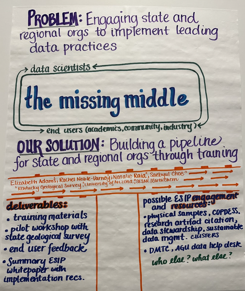
| Elizabeth Adams | Poster | Summer 2023 |
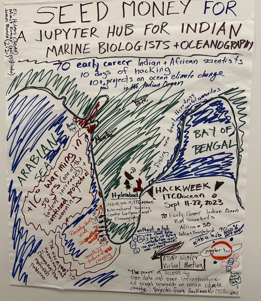
| Eli Holmes | Poster | Summer 2023 |
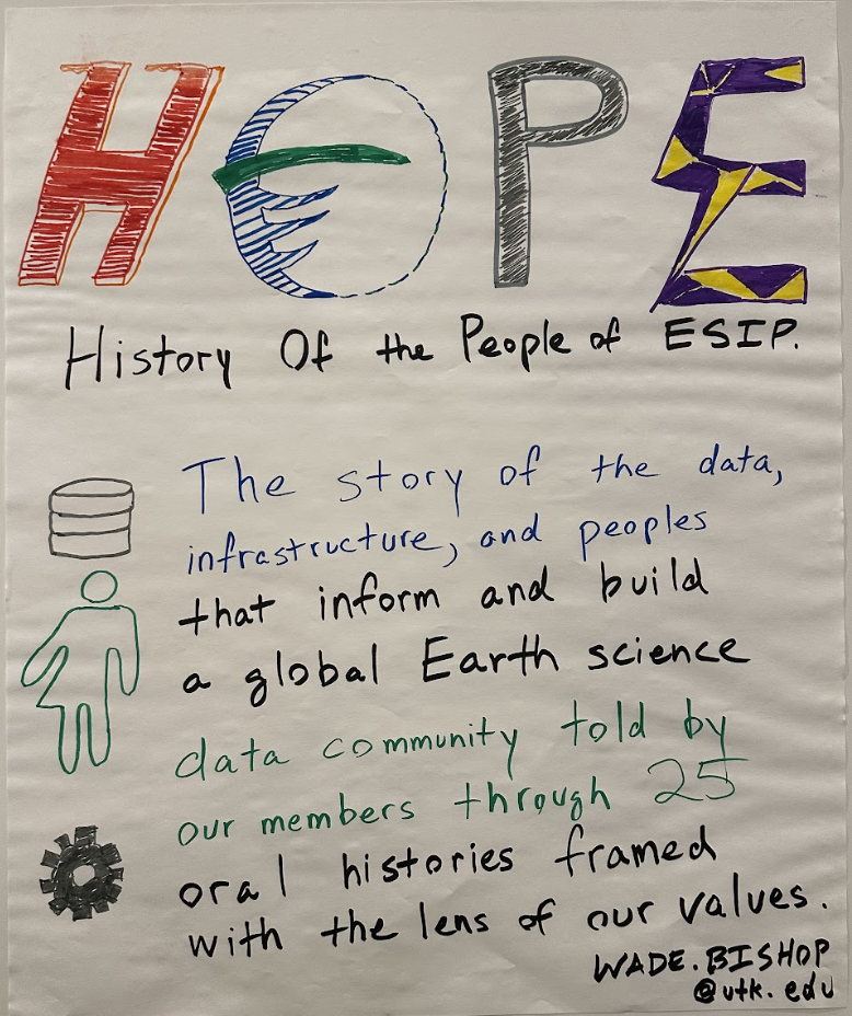
| Wade Bishop | Poster | Summer 2023 |
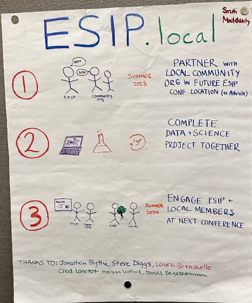
| Sruti Modekurty | Poster | Summer 2023 |
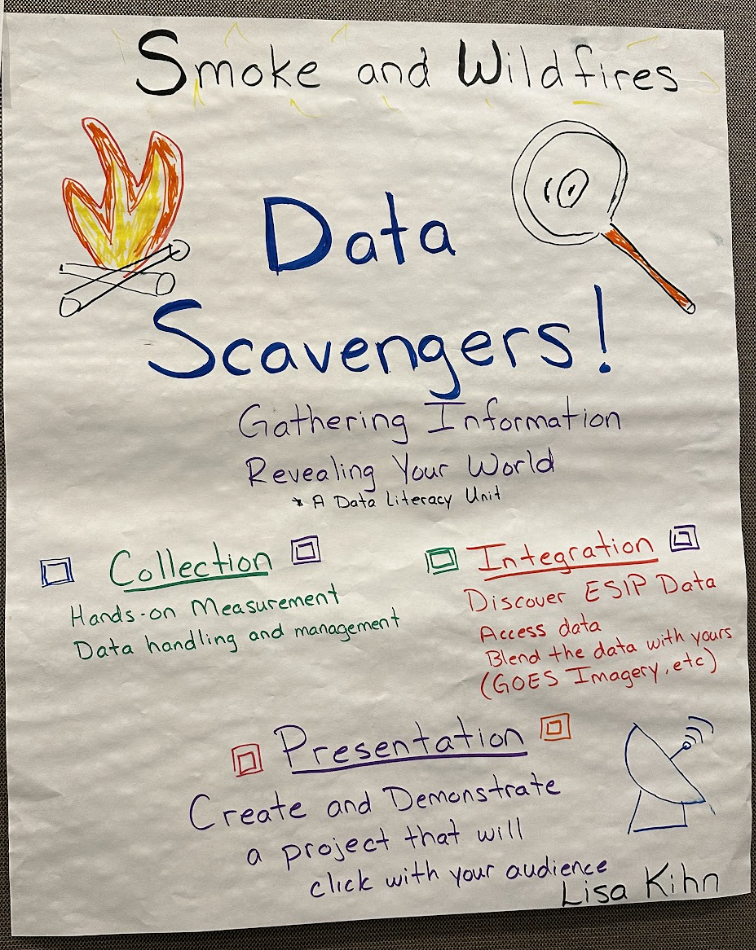
| Lisa Kihn | Poster | Summer 2023 |
| Vicky Gorman | Poster | Summer 2023 |
2022 Winners
| Project Owners | Poster | Funding Cycle |
|---|---|---|
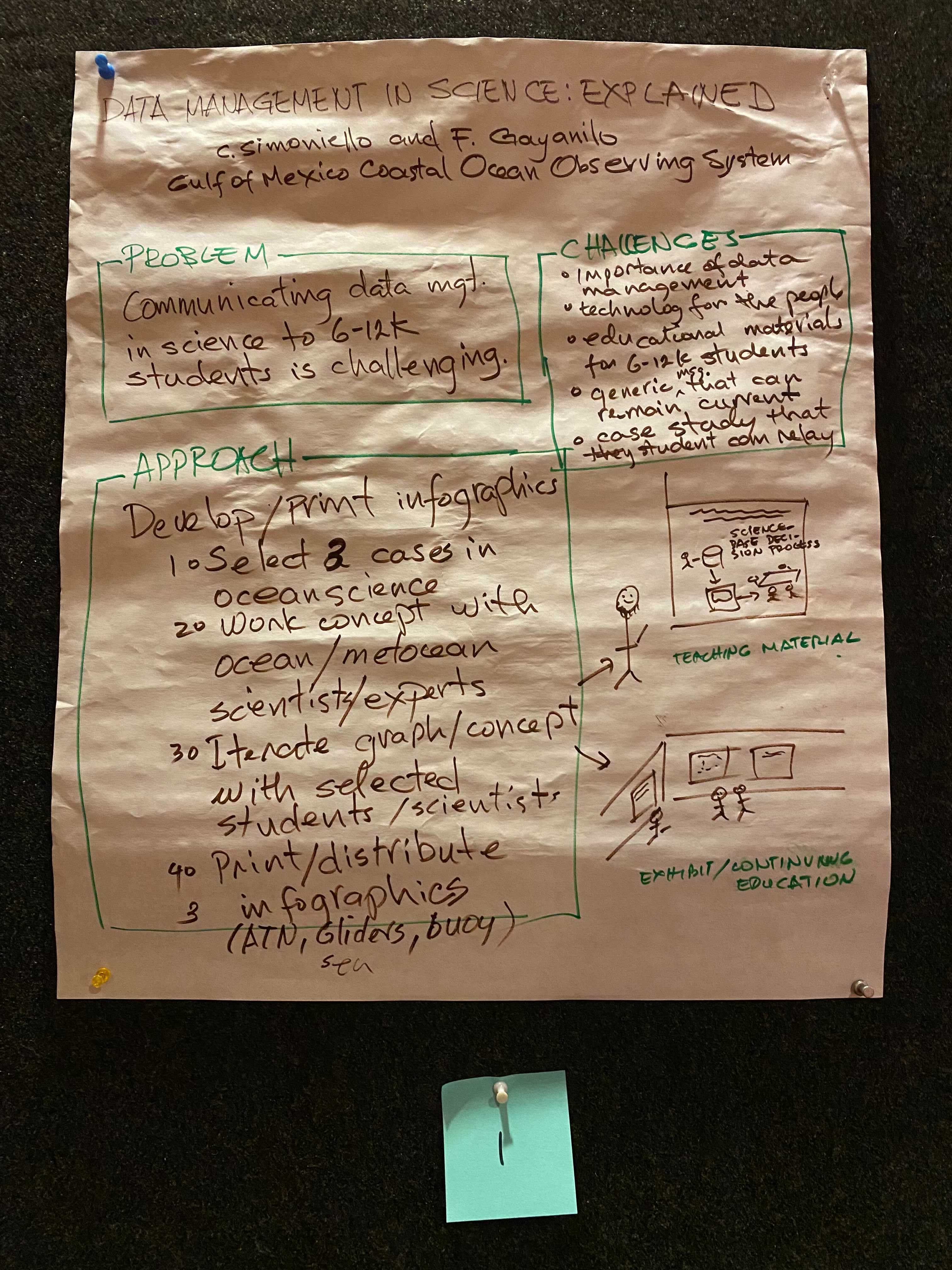
| Chris Simoniello | Poster | Summer 2022 |
| Brian Callahan | Poster | Summer 2022 |
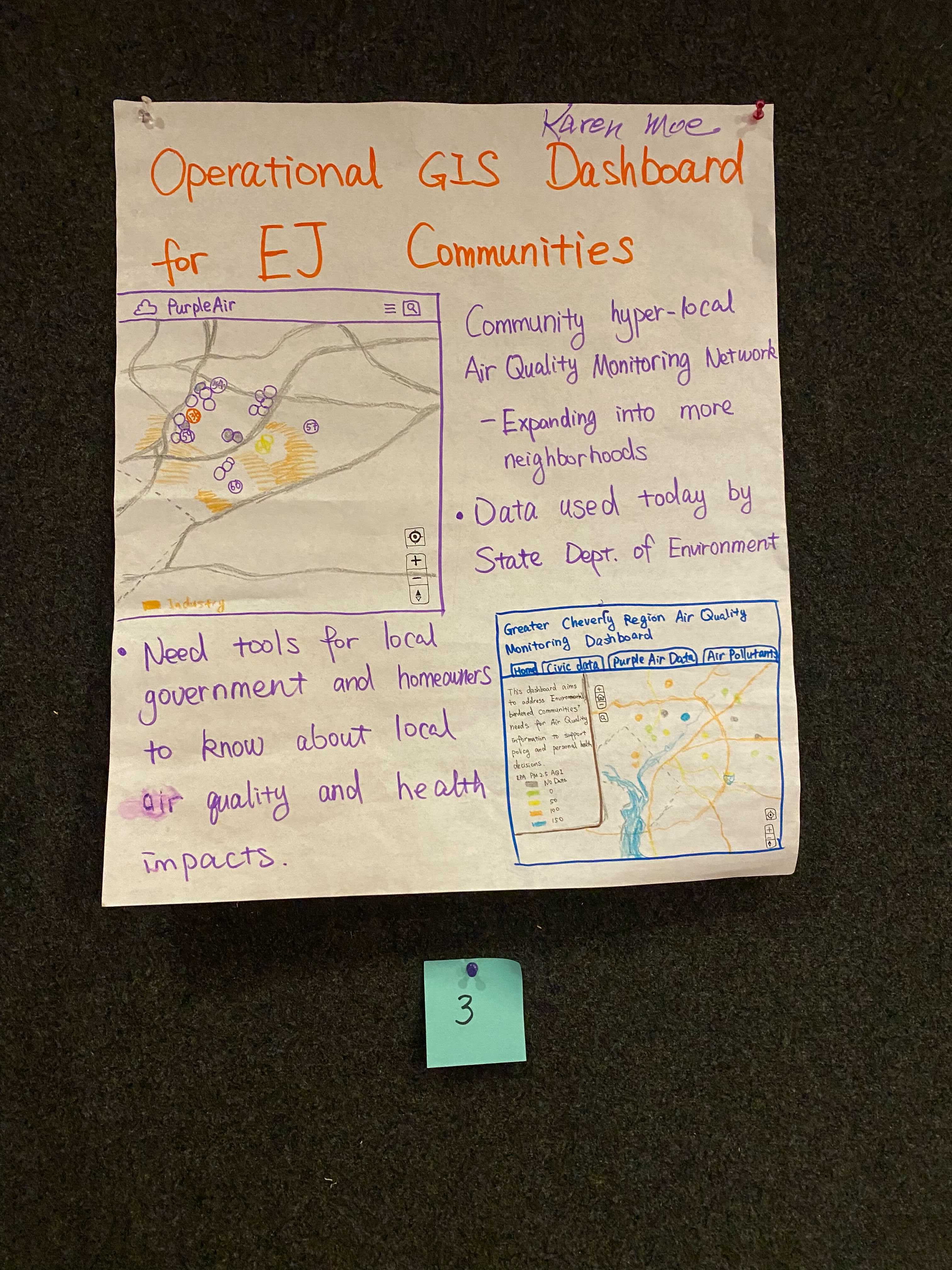
| Karen Moe | Poster | Summer 2022 |
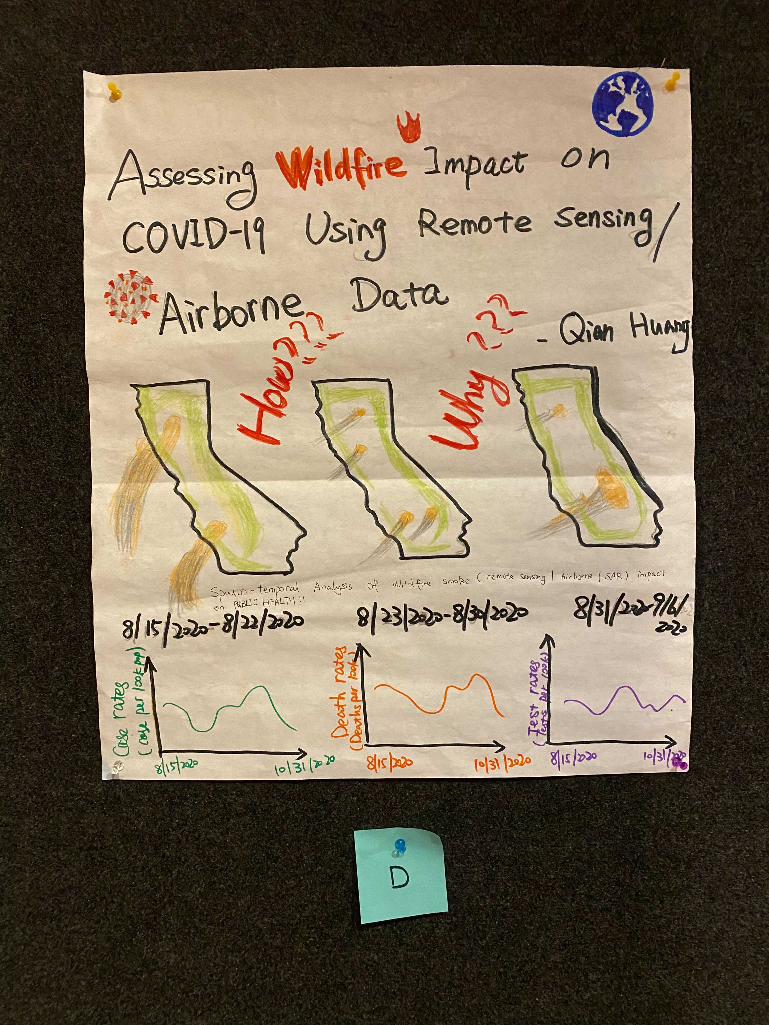
| Qian Huang | Poster | Summer 2022 |
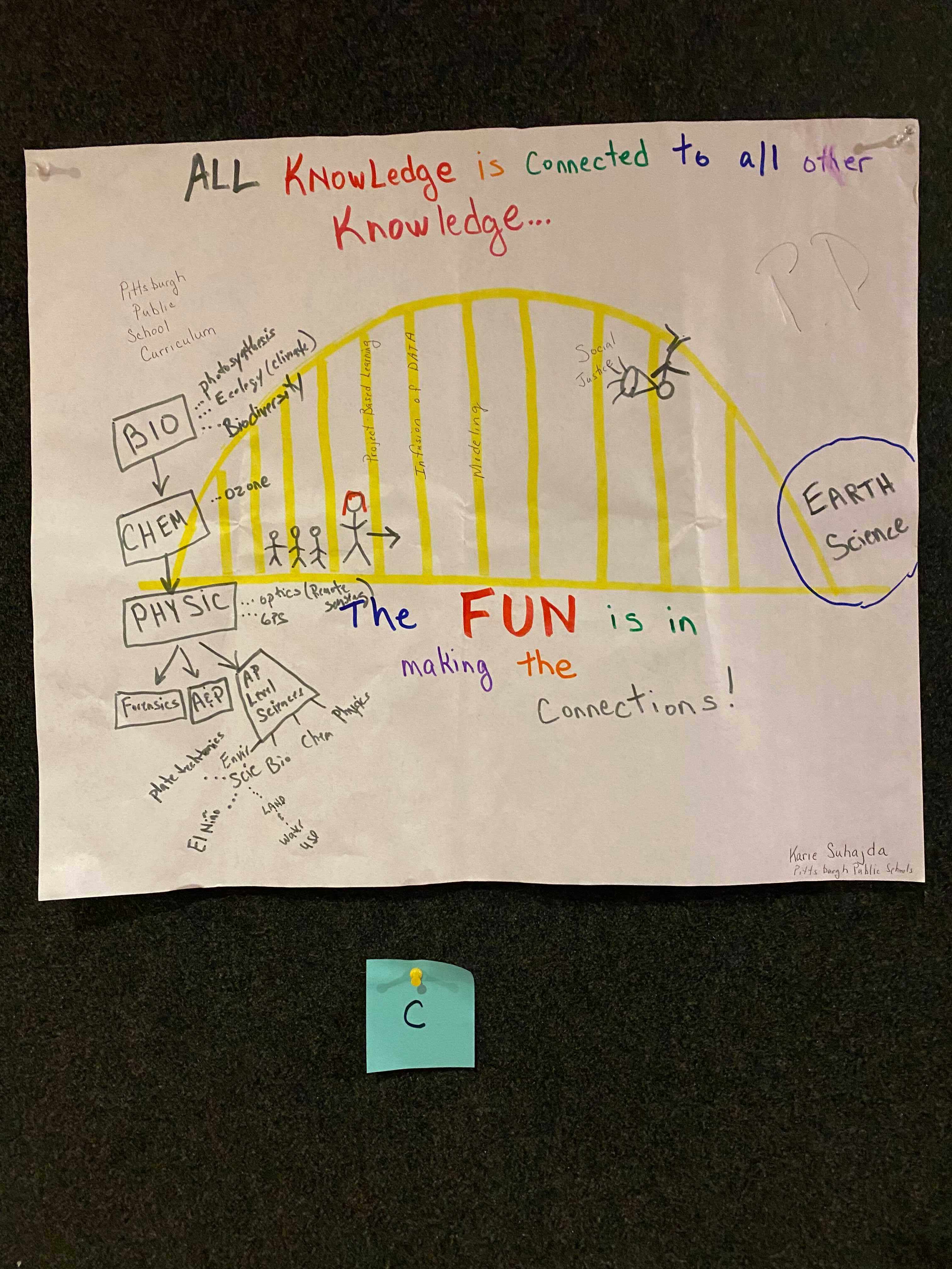
| Karie Suhajda | Poster | Summer 2022 |
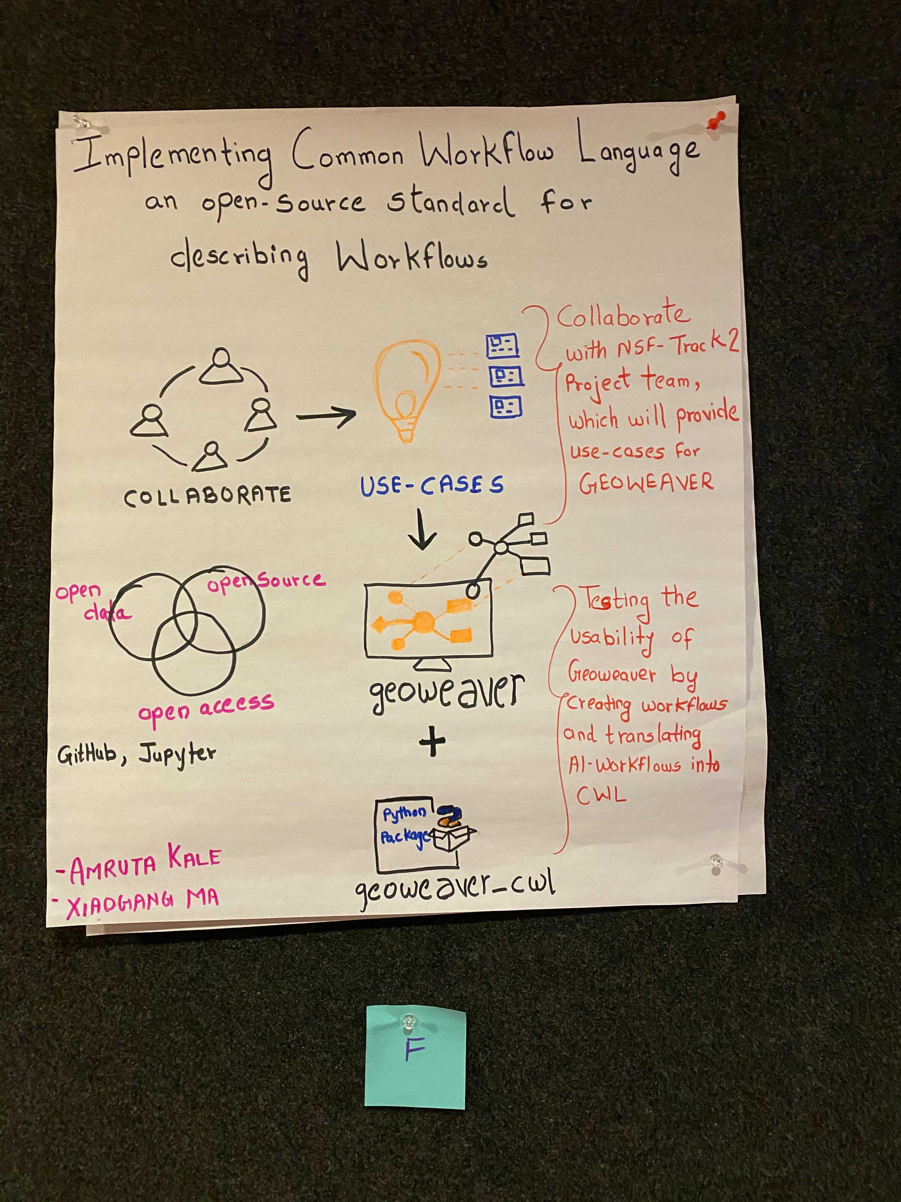
| Amruta Kale | Poster | Summer 2022 |
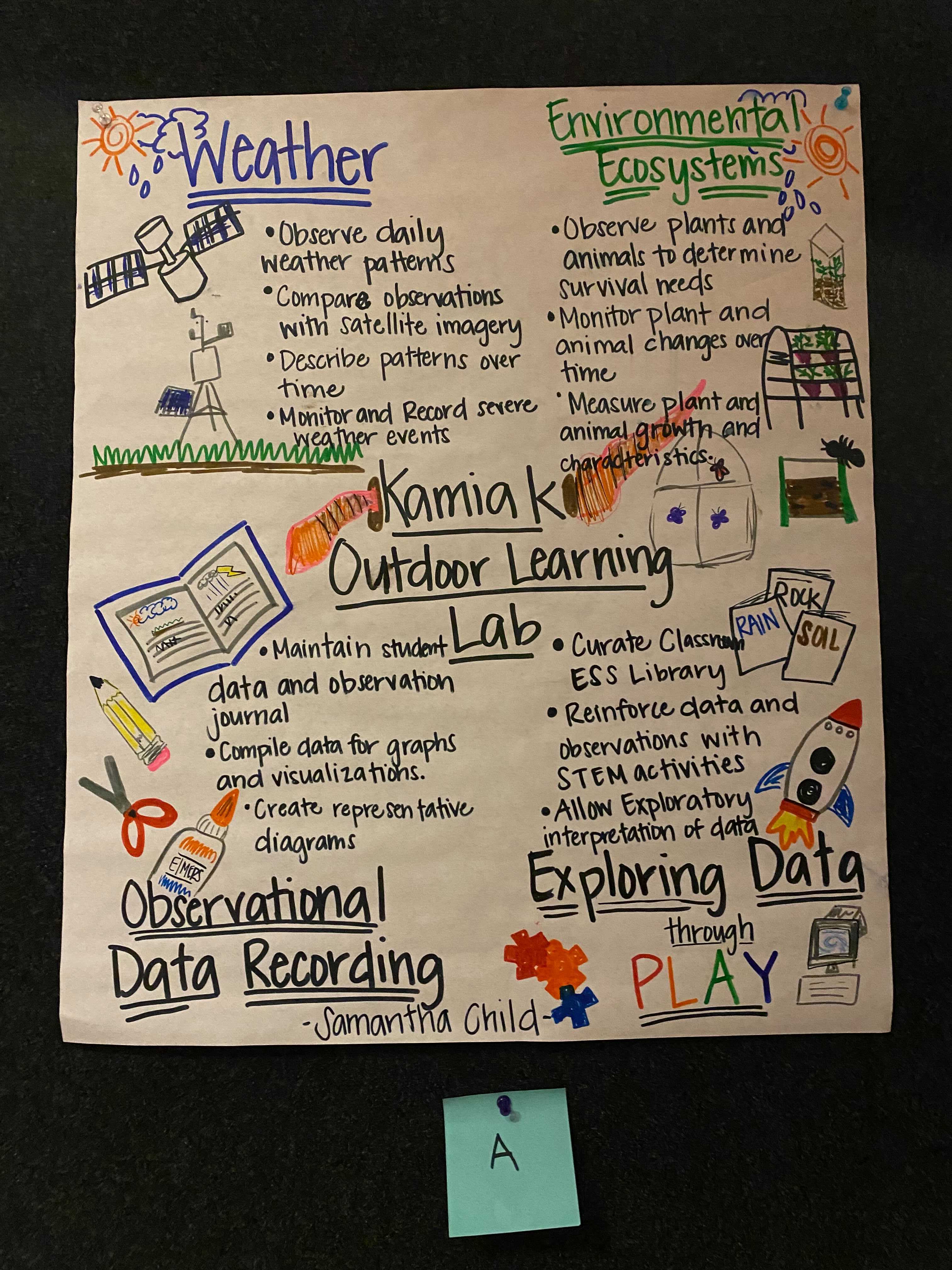
| Samantha Child | Poster | Summer 2022 |
2021 Winners
| Project Owners | Poster | Funding Cycle |
|---|---|---|
| Ryan McGranaghan | Summer 2021 | |
| Thilanka Munasinghe | Summer 2021 | |
| Megan Raisle | Summer 2021 | |
| Eric Walters | Summer 2021 | |
| Jessica Elliott |
Summer 2021 | |
| Rebecca Walters |
Summer 2021 | |
| Mimi Walker |
Summer 2021 |


2020 Winners
| Project Owners | Title | Poster | Winter Meeting Poster Node | Funding Cycle |
|---|---|---|---|---|
| Amber Budden (DataONE/NCEAS), Daniella Lowenberg (CDL), Shelley Stall (AGU), Denise Hills (GSA), Erin McLean (Arctic Data Center), Rob Crystal Ornelas (ESS-DIVE), Kristin Vanderbilt (EDI) | Why is this so hard? | File:BUDDEN.pdf | URL | Summer 2020 |
| Robert Rovetto | Semantic Orbital Sweep | File:ROVETTO.pdf | URL | Summer 2020 |
| Sarah Ramdeen | Deep Time Climate Data | File:RAMDEEN.pdf | URL | Summer 2020 |
| Alexis Garretson | Columba | File:GARRITSON.pdf | URL | Summer 2020 |
| Jake Hinz | SOS Explorer | File:HINZ.pdf | URL | Summer 2020 |
| Steven Martell | Drone Data for Schools | File:MARTELL.pdf | URL | Summer 2020 |
2019 Winners
| Project Owners | Title | Summary | Winter Meeting Poster Node | Funding Cycle |
|---|---|---|---|---|
| Yuhan Rao, Anne Wilson, Nancy Hoebelheinrich | Tutorials: Introducing Machine Learning | URL | Summer 2019 | |
| Ted Habermann | Identifying ESIP Connections | URL | Summer 2019 | |
| Chao Ma, Marshall Ma | Deep Time Climate Data | URL | Summer 2019 | |
| Ben Roberts-Pierel, Ellie Davis | Bill-ding Bridges: Data informing policy | URL | Summer 2019 | |
| Rose Borden, Katy Rico | Developing a Series of Flexible Modules for Community College Earth Science Students | URL | Summer 2019 | |
| Marguerite Walker | Dive Into Data | URL | Summer 2019 |


2018 Winners
| Project Owners | Title | Summary | Winter Meeting Poster Node | Funding Cycle |
|---|---|---|---|---|
| James Gallagher , Bob Simmons | Harvesting User Knowledge | URL | Summer 2018 | |
| Keith Maull, Ben Galewsky, Sean Gordon | A Searchable Repository of Notebook Metadata | URL | Summer 2018 | |
| Shayna Skolnik | Are you a climate warrior? | URL | Summer 2018 | |
| Connor Scully-Allison | Automatic Database & Microservice Generation from Structured Ontologies | URL | Summer 2018 | |
| Ranalda Tsosie | How's your H2O | URL | Summer 2018 | |
| Patrick Chandler | Now Hear This: An Audible Data Experience | URL | Summer 2018 |


2017 Winners
| Project Owners | Title | Summary | Winter Meeting Poster Node | Funding Cycle |
|---|---|---|---|---|
| Ruth Duerr, Reid Boehm | A 20-year Surprise | URL | Summer 2017 | |
| Beth Huffer | Earth Science Idol | URL | Summer 2017 | |
| Ryan Bowe, Gary Motz | Photogrammetric Metadata | URL | Summer 2017 | |
| Matt Bartos | Automated Sensor Firmware | URL | Summer 2017 | |
| Lori Baker | Data, Drones & Great American Eclipse | URL | Summer 2017 | |
| Deborah Gaff | Collecting Data that Matters - Physical Computing | URL | Summer 2017 |


2016 Winners
| Project Owners | Title | Summary | Winter Meeting Poster Node | Funding Cycle |
|---|---|---|---|---|
| Sean Gordon | Making Metadata Easy with Geonetwork | URL | Summer 2016 | |
| Kate Young, Janine Aquino | Pimp My Drone | URL | Summer 2016 | |
| Denise Hills, Kim Hines, Steve Diggs, Ismael Simley | Questionable Community Continuity | URL | Summer 2016 | |
| Sam Silva (Student Award) | Understanding Vegetation Through Social Media | URL | Summer 2016 | |
| Ed Flathers (Student Award) | Meanwhile, in dataland | URL | Summer 2016 | |
| Tammy Glover (Teacher Award) | Can we do... Sustainable? | URL | Summer 2016 | |
| Kalo Haslem (Teacher Award) | The use of STEM and Drones in the Middle School Classroom to Assist Student Learning | URL | Summer 2016 |


2015 Winners
| Project Owners | Title | Summary | Winter Meeting Poster Node | Funding Cycle |
|---|---|---|---|---|
| Sean Barberie (student award) | HumanHAB | HumanHAB is an exploratory project to explore what data sets and statistical indicators may better represent the nuanced impressions that people have about these complicated human habitats. Some potential indicators that will be explored are: walkability and public transit, local-businesses versus chains, and correlation exceptions... This project is highly exploratory, and the methods and relevant indicators will change and develop with the project. | Deferred till Summer 2016 | Summer 2015 |
| Brandon Whitehead (student award) | Semantic models for the ESIP community | ...Semantic matching of orthogonal facets of the ESIP community could provide some semblance of an enhanced search (and perhaps visualization component) along with an understanding of where the community has been (conceptually) versus where it may be going. More broadly, the proposal aims to capture the emergent structures, patterns, or clusters of information prevalent in within the community. | Deferred till Summer 2016 | Summer 2015 |
| Sarah Ramdeen (student award) | Stewardship of physical data, Use case and community engagement | ESIP supports a wide variety of work related to earth science information. One prominent group within ESIP is the Data Stewardship Committee... Given the overwhelming activities the Data Stewardship Committee is working on, there is a need to explore an ESIP cluster to focus on this narrow subset and to act as a leader among this community. The project will develop a use case describing the existing issues related to stewardship of physical data and work on building connections between these diverse communities. | http://commons.esipfed.org/node/8771 | Summer 2015 |
| Sophie Hou (student award) | Roadmap for the Next Generation Data Management Training Modules | From 2011-2103, ESIP partnered with NOAA and the Data Conservancy to produce the current version of the “ESIP Data Management for Scientists Short Course”. To understand the current needs for data management training and to build effective training resources, the Committee would like to assess the current landscape Data Management Training (DMT) resources. This project will contribute to the Committee’s roadmap as well as determining potential collaborators for the ESIP Short Course. | http://commons.esipfed.org/node/8763 | Summer 2015 |
| Soren Scott (full award) | A Github Badging System | Github badges provide a quick and visual way to indicate build status, code coverage or participation in crowdfunding opportunities. There is a desire in the ESIP community to acknowledge participation in ESIP collaborations without requiring (or creating the expectation) that a project repository be hosted under the ESIP Federation Github organization... This project proposes a system of badges that can be included in a project’s README documentation as a simple branding activity. | http://commons.esipfed.org/node/8760 | Summer 2015 |
| Wade Bishop (full award) | Harvesting Information Partnerships for Geospatial data Education and Outreach (HIPGEO) | The HIPGEO project will create a potential partner directory to grow ESIP institutional membership. This list combined with existing members also provides a useful sampling frame for job analyses to inform the earth data science curriculum. | http://commons.esipfed.org/node/8969 | Summer 2015 |
| Shelley E. Olds (full award) | Interactive Interface To Explore Natural Hazards And Vulnerability In Coastal Communities | Along the coast of the Pacific Northwest a massive earthquake could occur at anytime. Residents and visitors often aren’t familiar with how to prepare or respond. In this project, an interactive map will provide an interface to explore hazards and vulnerability data available for the coastal Pacific Northwest. | http://commons.esipfed.org/node/8815 | Summer 2015 |
2014 Winners
| Project Owners | Title | Summary | Winter Meeting Poster Node | Funding Cycle |
|---|---|---|---|---|
| Bruce Caron, Adam Shepherd | Working Group Syndicated Content Tool | Similarly focused working groups across organizations such as ESIP, Research Data Alliance (RDA) and EarthCube (EC) could share content from their respective online website workspaces through a syndicated RSS feed for display on the other related working group websites. Coincidentally, all of these sites run on the Drupal platform, for which, the EOSDIS group developed code, or Drupal module, that syndicates content across multiuple Drupal sites – the Earth Data Federated Content Tool (ED-FCT). | TBD | Summer 2014 |
| Kaijian Xu | Rich Semantic Annotation for Science Media Repositories | This project provides a new framework for a highly expressive, descriptive annotation of multimedia content like images, video, etc. in scientific repositories, using a language structure that is inspired by word classes (e.g. nouns, verbs, etc.) in everyday (“natural”) languages. Such a framework would be used to capture and represent rich, semantic annotations about what objects and features are present within the scene, the interactions between them, as well as further describe such objects and interactions. | http://commons.esipfed.org/node/7864 | Summer 2014 |
| Kelly Monteleone | Converting mb-system Files in Windows and Apple | Mb-system is a unix based program for multibeam sonar (Bathymetry) data. Mb-system was supported by NOAA from 2002 to 2004. It does not work in windows and is complicated to install and use. Goal: Create a one click installer that will install Cygwin, mb-system, and supporting files on a windows system. And pull out a python wrapper for Apple and non-cygwin installation. This will provide a GUI to export the data in xyz, ascii, and GeoTIFF. | http://commons.esipfed.org/node/7760 | Summer 2014 |
| Kevin Dobbs | Leveraging the Power of Google Earth Engine to Derive High Quality Water Reference Data for Flood Disaster Decision Support | At the 2014 Summer ESIP meeting a poster was created and presented based on the idea that American emergency response agencies can utilize aquaponics systems after a disaster event has occurred in any region. It is imperative that the aquaponics systems be suited for the region based on climate and population and that the people of the area are taught how to use and maintain the systems. Through the use of technologies such as Esri ArcMap, Worldview, iRODS, ect. geospatial data from a variety of DAACs will be used to pre-plan for a case study on a particular region. | http://commons.esipfed.org/node/7871 | Summer 2014 |
| Kyle Nelson | Enhancing and Educating with the WxSat Mobile App | At the 2014 Summer ESIP meeting a poster was designed and presented to promote the idea of building upon the successful WxSat app (iOS and Android) that allows users to view global visible, infrared and water vapor satellite data on mobile devices. Current products are viewable in black and white but color enhanced imagery can allow for ease of identification of key weather features. Satellite imagery is becoming more prevalent with ease of access online and is being displayed increasingly often on local and national weather segments. To enhance the understanding of the all who view satellite data, an educational tutorial will be created with case studies for all three imagery types. Meteorological phenomena will be identified through annotated still and animated images to provide a conceptual model for the user to apply when viewing satellite imagery in real time via the WxSat app or another source. | http://commons.esipfed.org/node/7860 | Summer 2014 |
| Lee Hyokyung | HDFCRAFT – Making Earth Data Fun! | At the 2014 Summer ESIP meeting a poster was created and presented based on the idea that NASA HDF/HDF-EOS data products can be used for Minecraft game. Minecraft stores its world maps in Anvil file format that has similar characteristics that HDF has. By converting NASA HDF data into Minecraft map, kids and educators can play with NASA Earth Data easily in 3D. | http://commons.esipfed.org/node/7742 | Summer 2014 |
| Matt Ferrito | ToolMatch Extension | The ToolMatch project was based upon the idea of semantic matching of data collections and tools that could be used with those data collections. Specifically, two use cases were developed for the service: 1. Search for the tools that can be used with a given data collection, and then find out what the tool can do with the data collection. 2. Search for collections that can be used with their tool, and capture information about what the data user would like to be able to do with their data. The poster created and presented at the 2014 ESIP Summer Meeting was based upon the idea of an extension of the second use case. This extension involves the semantic matching of data collection content with applicable tools. This matching is stricter than than matching based upon information about the data collection, but the use case itself is broader in scope. Ex: Given rainfall or topology measurements, determine which tools within a hyrdologoical model can be used with the data content. This will allow the appropriate tools within the model to be used with the matching data collection content. | http://commons.esipfed.org/node/7735 | Summer 2014 |
| Linyun Fu & Massimo Di Stephano | Towards Automatic Provenance Capturing for Research Publications | Provenance information is critical for research publication readers to correctly interpret report content and enables them to evaluate the report by digging into the software in use, source data and responsible agents. However, creating proper provenance information for research publications is very hard. We propose a project to develop a platform that can automatically capture provenance information in the process of preparing publications. The idea is that authors just need to do their regular authoring jobs on the platform without caring about provenance, which is captured by the library functions of the platform in an non-distracting manner. | http://commons.esipfed.org/node/9137 | Summer 2014 |
2013 Winners
Member Winners
- Demonstration of a mobile application for estimating forest canopy closure using digital photographs
- Making the Case for Data Stewardship Use Cases: A Community Building and Engagement Exercise
- Semantic Similarity Computation and Concept Mapping in Earth and Environmental Science
Student Winners
Other FUNding Friday-inspired projects:
CheapStix: Distributing and Running OPeNDAP servers on a Virtual Machine
1-Click Satellite Data: A Java applet that let's you display current satellite data anywhere in the world with one simple mouse click.
2012 Winners
Member Winners
- Climate Change – One Student @ a Time
- Exploratory visualization of earth science data in a Semantic Web context
- Preprint Service with Open Review
- Revitalizing Forgotten Data: Bringing 40 years of Glacial Photography into the Digital Age
Student Winners
- Assessing Skills, Access and Trust of Data Use and Reuse within the ESIP community
- Interactive Federation Network Analysis Tool
2011 Winners
Member Winners
- Demonstrating preservation connections using OAI-ORE
- Digital Earth Watch in Action
- Enhanced Collaborative Disaster Management Through Interoperable Data Visualization
- Linked Open Research Data for Earth and Space Science Informatics
Student Winners
- Engaging Climate Change Learners in Public School Settings
- Self-Organizing Maps for Automated Oil-Spill Detection
2010 Winners
Member Winners
Student Winners
- Beaver Creek Project
- Campbell-Stokes Sunshine Recorder Charts Project
- State Tectonics Project
- Spatial Cloud Project
2009 Winners
Member Winners
Student Winners