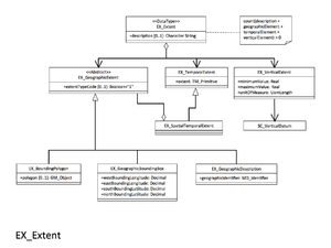
EX VerticalExtent
From Earth Science Information Partners (ESIP)
gex:EX_VerticalExtent
Minimum and maximum vertical extent of the resource. Recommended if your resource has vertical coverage.
| Elements | Domain | Definition and Recommended Practice | Examples | ||
|---|---|---|---|---|---|
| 1 | gex:minimumValue | 1 | gco:Real | Lowest vertical extent contained in the dataset. | minimumValue: 3600 |
| 2 | gex:maximumValue | 1 | gco:Real | Highest vertical extent contained in the dataset. | maximumValue: 3100 |
| 3 | gex:verticalCRSId | 0..1 | mrs:MD_ReferenceSystem | Mandatory if gex:verticalCRS is not present | |
| 4 | gex:verticalCRS | 0..1 | CRS (need more info) | Mandatory if gex:verticalCRSId is not present Vertical coordinate reference system. Recommend referencing EPSG codes with an XLink instead of populating this section. |
verticalCRS:
|


